

Thursday delivered exactly what we promised - beautiful sunny skies and temperatures climbing into the low 80s across the Treasure Valley. If you got outside to enjoy it, you made the right call. But we're not done with the warm weather just yet.
Friday brings more of the same perfection
We're doubling down on Thursday's success with another gorgeous day ahead. Friday will serve up sunny skies and highs around 81 degrees - nearly identical to what we just experienced. Those helpful southeast winds will continue at a comfortable 7-14 mph, making it feel just right for any outdoor plans you might have.
If Thursday felt perfect, Friday should feel like a repeat performance. It's the kind of weather that makes you want to extend your lunch break or find an excuse to be outside.

The weekend reality check approaches
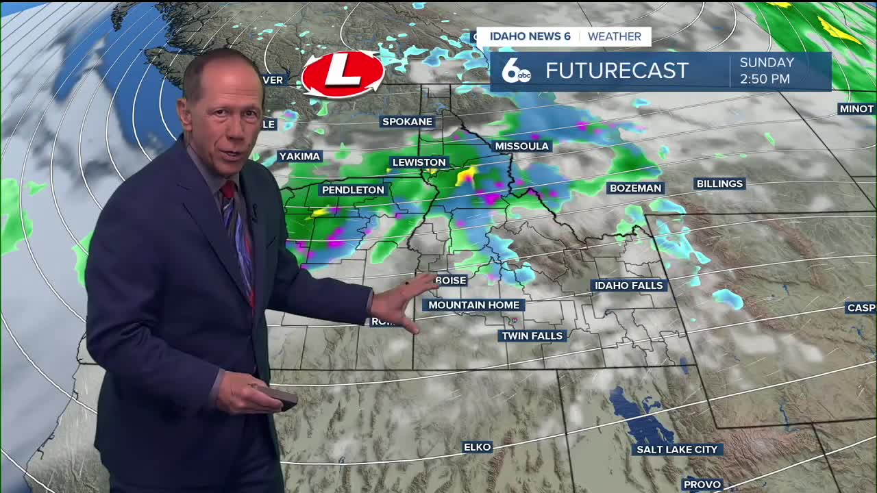
While we're basking in this 80-degree paradise, a weather system is organizing off the Oregon coast that's about to completely change our weather story. Friday evening marks the beginning of the shift as a cold front approaches our area.
Late Friday night, showers will start spreading across the region, but here's the important distinction: the Treasure Valley will see only about a 30% chance of light rain, while our neighbors in the central mountains face much more significant weather.
The Boise Mountains and west-central Idaho are looking at 60 to 80% chances of rainfall thanks to upslope winds that'll pump moisture directly into the terrain. If you have weekend mountain plans, this is your heads-up to plan accordingly.

Saturday's dramatic turnaround
Saturday is when reality hits hard. We're talking about a temperature nosedive from Friday's comfortable 81 degrees down to just 63 degrees. That's an 18-degree drop in 24 hours.
The Treasure Valley will see mostly sunny skies Saturday morning with only a 20% chance of showers before noon. But Saturday night ramps up the rain chances to 40% as the system moves through. Winds will shift to the west-northwest with gusts between 12 to 22 mph Saturday afternoon, making that 63-degree reading feel even chillier.
Meanwhile, the central mountains will be dealing with a 60 to 80% chance of rain throughout the weekend, creating a stark contrast between valley and mountain conditions.

Extended outlook: Cooler pattern takes hold
Sunday continues the cooling trend with another 5 to 10-degree drop, bringing highs down to around 56 degrees. We'll see partly sunny skies with a 30% chance of morning showers in the valley - a far cry from our current 80-degree stretch.
The unsettled pattern settles in for the long haul through Monday and beyond. Daily shower chances hover around 30% for the Treasure Valley, with temperatures staying stuck in the upper 50s to low 60s. The central mountains will continue seeing much higher rain chances throughout the period.
By Wednesday, we see continued shower chances and highs around 55 degrees - a clear sign that our summer-like weather may officially be over.

Daily forecast
Tonight: Mostly clear, with a low around 58. South southeast wind 6 to 9 mph becoming north northwest in the evening.
Friday: Sunny, with a high near 81. East southeast wind 8 to 10 mph.
Friday Night: A slight chance of showers and thunderstorms, then a chance of showers after midnight. Partly cloudy, with a low around 50. Chance of precipitation is 30%.

Saturday: A 20% chance of showers before noon. Mostly sunny, with a high near 63.
Saturday Night: A 40% chance of showers AFTER MIDNIGHT. Mostly cloudy, with a low around 42.
Sunday: A 30% chance of showers before noon. Partly sunny, with a high near 56.
Monday: A 30% chance of showers, mainly before noon. Partly sunny, with a high near 61.
Tuesday: A 30% chance of showers. Partly sunny, with a high near 59.
Wednesday: A 30% chance of showers. Patchy fog. Otherwise, partly sunny, with a high near 55.
Stay connected right here for updates on my forecast for changes this weekend!