


An elongated trough off the West Coast, tied to a closed low near British Columbia and another disturbance sliding toward California, is sending a cooler weather maker our way. The associated front will reach southwest Idaho this evening and stall over the Treasure Valley and central mountains through Friday, keeping rain and unsettled conditions in place into the weekend.
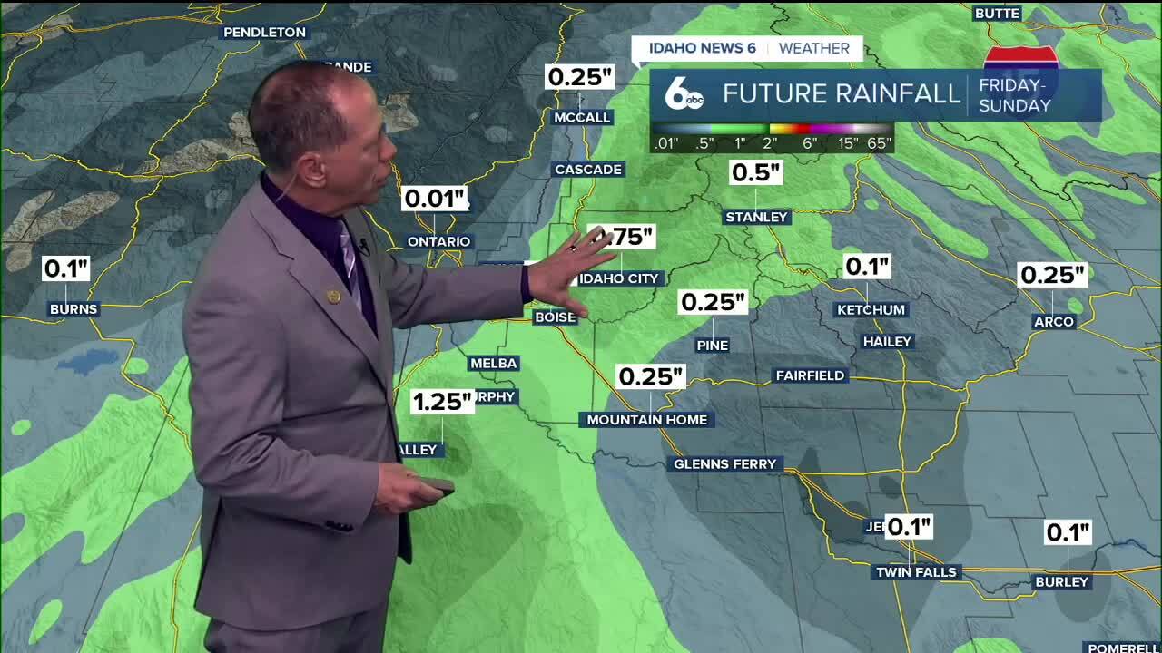
Rainfall Outlook
Rain will be variable across the region. The Treasure Valley and central Snake Plain are expected to pick up 0.25″ to 0.65″ of rain, with the heaviest corridor running from Nampa through Mountain Home and stretching from the Owyhees, Idaho City, Lowman, Warm Lake, and Yellow Pine, where we could see 0.75″ to 1.25″ by midday Friday. The Wapiti burn scar and Banner Summit are also in line for higher totals, raising concern for flash flooding, especially near vulnerable burn areas.
A Flash Flood Watch is in effect, especially near burn scars, where heavy rain could quickly trigger flooding or debris flows. Stay in tune with the forecast if you live in an area where flash flooding is likely. Remember the phrase "Turn around don't drown", never drive through flooded waters.

The unsettled weather won’t just stop at rainfall. As the front passes Friday night into Saturday, gusty winds will develop across the Snake Plain east of Boise, where sustained winds near 30 mph and gusts up to 45 mph are possible. Boise should see wind gusts 25-30 mph on Saturday.
Meanwhile, cooling behind the system will drop snow levels to around 7,000 feet by Saturday night, meaning light snow could coat the highest mountain peaks. Temperatures remain steady today, then cool 5–15 degrees on Friday in the front’s wake.

The trough will slowly slide eastward through Saturday, leaving lingering showers over southwest Idaho and southern Oregon. By Sunday, another weak disturbance may spark a few light showers in central Idaho, with a wintry mix possible in the higher elevations. Warmer temperatures will make for some very pleasant Autumn weather next week.
Bottom Line
Expect a soaking rain for Ada County and parts of the central mountains Thursday night into Friday morning, with the heaviest totals in the mountains. Breezy winds in the Treasure and Magic Valleys, and even a touch of early-season snow at the highest elevations. The main flash flood concern is for near the burn scars.
Stay Check out my updated video forecast for a soaking overnight rain!
Tonight
Showers and possibly a thunderstorm. Patchy fog after midnight. Low around 52. Locally breezy near any storms. Chance of precipitation is 90%. New rainfall amounts between a quarter and half of an inch are possible.
Friday
Showers likely (mainly in the morning), with thunderstorms also possible after noon. Otherwise, cloudy & chilly, with a high only near 63. Becomimg breezy late in the day. Chance of measurable precipitation is 60%.
Friday Night
Mostly cloudy with just a slight chance of a shower early, then gradually becoming mostly clear, with a low around 46. Northwest wind 9 to 11 mph, with gusts as high as 24 mph, diminishing late.
Saturday
Mostly sunny, quite breezy & chilly, with a high only near 64. NW wind 10 to 18 mph, with gusts as high as 25 mph.
Saturday Night
Mostly clear and colder, with a low around 41.
Sunday
Sunny with a chilly morning and a pleasant afternoon with light wind and a high near 63.

Monday
Sunny, with a high near 65.
Tuesday
Sunny, with a high near 68.
Wednesday
Sunny & pleasant, with a high near 71.
Wednesday Night
Clear, with a low around 47.
Thursday
Sunny & pleasant, with a high near 72.
Stay connected right here for updates to my forecast for overnight rain and for the weekend. You can always get my ScottScore Forecast on my Facebook Page.