


Low clouds were hanging around Treasure Valley locations Monday, while light showers developed over northern areas. A weather system moving through central California will keep our somewhat wet and cool pattern going through Wednesday before conditions finally start to improve.
Tonight through Wednesday: More rain on the way
The Treasure Valley will see another round of wet weather as a closed low-pressure system tracks through the region. Tonight brings a 30% chance of showers, mainly after midnight, with mostly cloudy skies and lows around 43 degrees.
Tuesday ramps up the activity significantly with showers likely and a 60% chance of precipitation. There's even a possibility of afternoon thunderstorms after 3 p.m. as warm southerly winds increase temperatures to around 64 degrees and create some instability.
The central mountains will see the most action from this system. Higher elevations above 7,000 feet could pick up to 2 inches of snow, while Treasure Valley locations will see minimal accumulations - generally less than 0.10 to 0.20 inches of rain.
Wednesday brings the heaviest rain
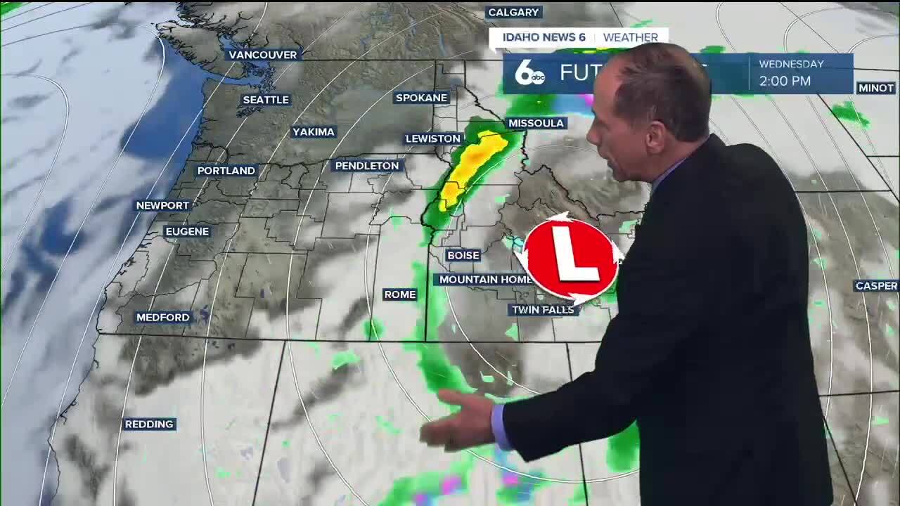
Wednesday morning delivers the most significant precipitation as the low-pressure system moves over the Utah-Nevada border. A band of heavy rain will sweep through the region from east to west, bringing the best chance for meaningful rainfall we've seen in this pattern.
The Treasure Valley can expect showers mainly before noon with a 60% chance of precipitation and patchy morning fog. Temperatures will be cooler, reaching only around 58 degrees as the system moves through.
Rain accumulations from Tuesday night through Wednesday could reach 0.20 to 0.50 inches across valley locations - a welcome sight for those hoping for more substantial moisture.

Central mountains see more snow
The central mountains will continue to be the big winners in this weather pattern. Snow levels will drop to 6,500 to 7,500 feet by Wednesday evening, bringing another 1 to 3 inches of snow to ridgetops during the heaviest showers.
Combined with earlier snowfall, mountain locations above 7,000 feet could see several inches of accumulation by Wednesday night - great news for those eager to see winter conditions developing in higher elevations.
Sunny weather returns Thursday
Thursday marks a dramatic shift as high pressure builds over the northern Pacific. The Treasure Valley will see patchy morning fog before 9 a.m., then sunny skies with highs around 60 degrees.
This begins a stretch of pleasant weather that continues into the weekend.
Weekend outlook: Best weather in days
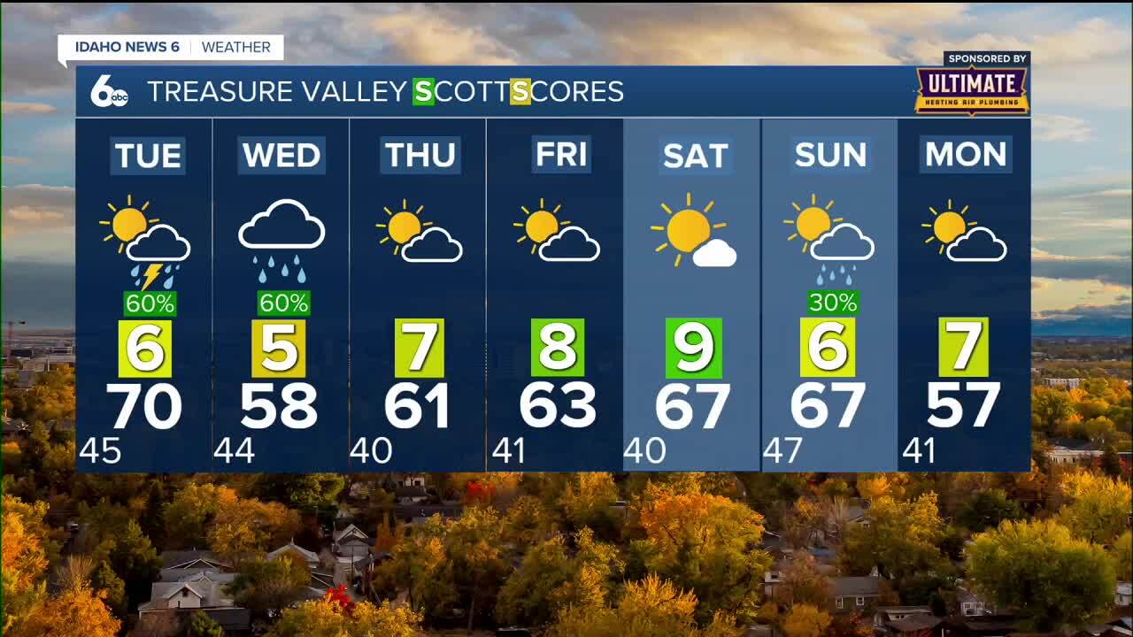
The weekend brings the nicest conditions we've seen in quite a while. Saturday looks especially appealing with sunny skies and highs around 64 degrees in Boise - perfect for any outdoor activities you've been postponing due to the recent wet weather.
Sunday starts sunny with a high near 66 degrees, though there's a 30% chance of showers developing as another system approaches from the coast.
Next week: Another change coming
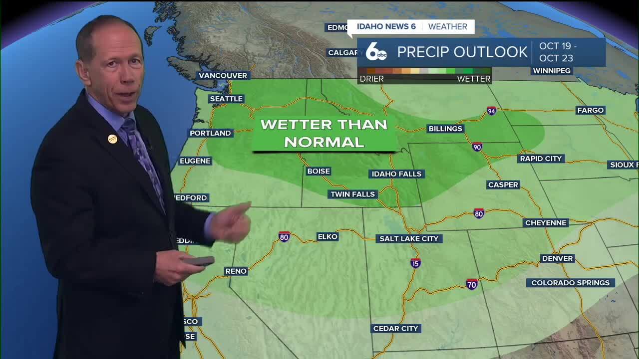
By Sunday night into Monday, another weather system approaches the coast. This could bring 40 to 50% precipitation chances, drop snow levels to 5,000 feet, and push temperatures about 10 degrees below normal.
Monday shows a 20% chance of showers with highs around 55 degrees - a reminder that our fall weather pattern remains active even during the pleasant stretches.
Daily forecast
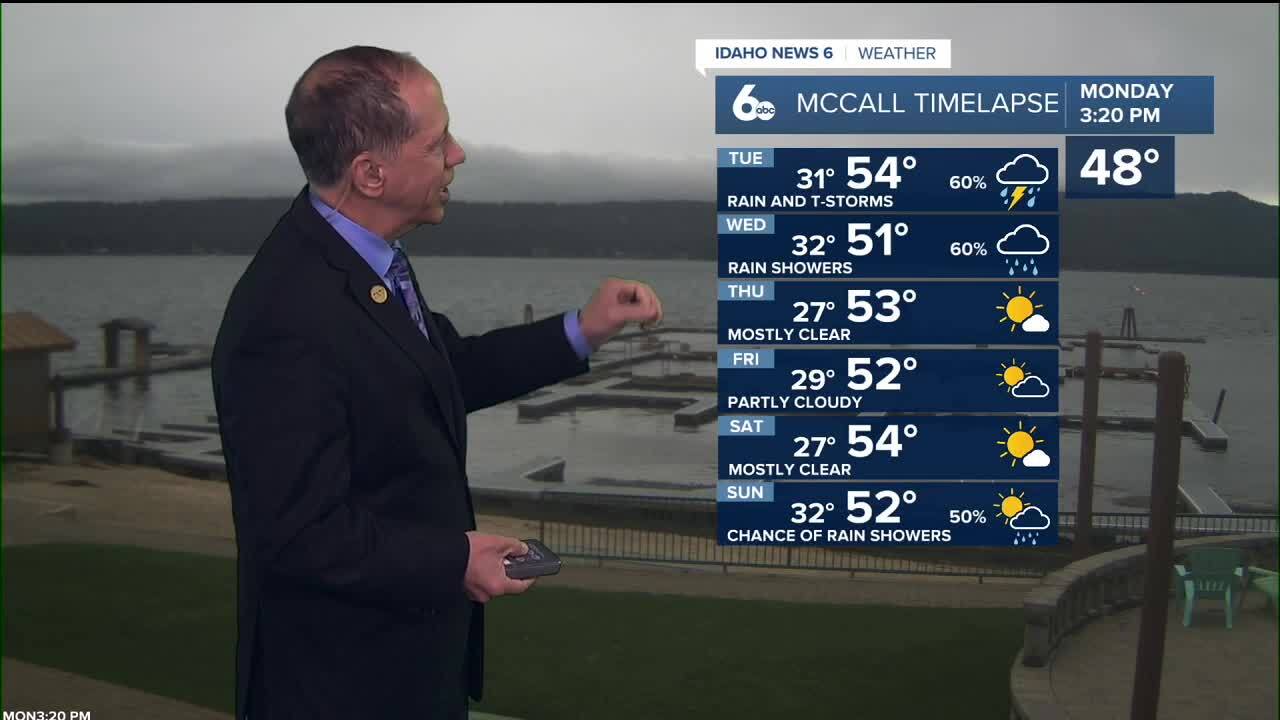
Monday night: 30% chance of showers after midnight. Mostly cloudy with a low around 43°. Light wind.
Tuesday: Showers likely with possible afternoon thunderstorms after 3 p.m. Mostly cloudy and a little milder with a high near 64°. Wind SE 6-12 mph. 60% chance of precipitation.
Tuesday Night: 40% chance of showers after midnight. Partly cloudy with a low around 43°. Light wind.
Wednesday: Showers likely before noon. Patchy morning fog. Mostly cloudy & cool with a high near 58°. Light wind. 60% chance of precipitation.
Thursday: Patchy fog before 9 a.m. Otherwise sunny with a high near 60°.
Friday: Mostly sunny with a high near 62°.
Saturday: Sunny and pleasant with a high near 64°.
Saturday Night: Mostly clear with a low around 47°.
Sunday: 30% chance of showers. Mostly sunny with a high near 66°.
Monday: 20% chance of showers. Mostly sunny with a high near 55°.
Stay connected right here for updates to my extended forecast into the weekend, and be sure to check out my ScottScore Forecast on my Facebook Page