

The Treasure Valley is in for a spectacular weekend with sunny skies and mild temperatures, but ski enthusiasts will need to be patient as snow won't reach area mountains until the end of next week.

High pressure building over the region will deliver picture-perfect conditions through mid next week. Mostly clear skies will dominate, with only patchy morning fog possible in some mountain valleys.

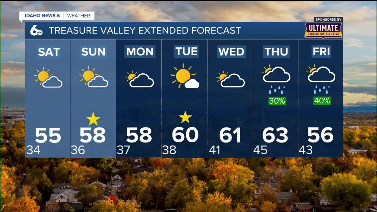
Weekend forecast details
Saturday brings sunny skies with highs near 56 degrees and calm winds - ideal conditions for any outdoor activities. Saturday night will be partly cloudy with lows around 36 degrees.
Sunday continues the pleasant trend with mostly sunny skies and highs climbing to 59 degrees. Light and variable winds will make it feel even more comfortable.
A temperature inversion will develop over the weekend, meaning mountain locations will actually be warmer than the valleys. While valley temperatures will run several degrees above normal, mountain areas could see temperatures around 10 degrees above normal by Sunday.

Extended mild pattern continues
The beautiful weather doesn't stop with the weekend. Large-scale ridging will maintain dry conditions and a slight warming trend Monday through Wednesday.
Tuesday looks particularly nice with sunny skies and highs near 61 degrees - perfect for outdoor events.
Peak temperatures will slowly climb into the lower to mid-60s throughout next week, with Thursday expected to be the warmest day. Maximum temperatures could reach the upper 60s on Thursday, making it feel more like early October than mid-November.

Snow outlook for ski areas
For those eagerly awaiting ski season, the news requires patience. No snow is in the forecast through Wednesday.
The first real chance for mountain snow won't arrive until late in the week. A large upper-level trough system is expected to move into the Northwest region late Wednesday through Friday, finally bringing precipitation and cooler temperatures.
Thursday will see a 20-40% chance of precipitation in the valleys and 50-60% in the west-central mountains. Friday brings more widespread precipitation with 40-50% chances in valleys and up to 70% in the mountains.
Even then, snow levels will only slowly drop into the 6,000 to 7,000 foot range by Friday, meaning significant snowfall for ski areas remains unlikely until the very end of next week at the earliest.

Daily forecast
Friday Night: Mostly clear, with a low around 34 degrees. Diminishing NW wind.
Saturday: Sunny with a very nice afternoon and a high near 56 degrees. Calm wind.
Saturday Night: Partly cloudy, with a low around 36 degrees. Calm wind.
Sunday: Mostly sunny & pleasant, with a high near 59 degrees. Light and variable wind.
Monday: Partly sunny & unseasonably mild, with a high near 60 degrees.
Tuesday: Sunny & unseasonably mild, with a high near 61 degrees.
Wednesday: Partly sunny, with a high near 62 degrees.
Thursday: Partly sunny & continued unseasonably mild with a 30% chance of rain later in the day. High near 64 degrees.
Friday: Partly sunny with a 50% chance of rain and a high near 57 degrees.
Stay connected right here for updates to our weather through next week!