

The mountain snowstorm that impacted western Idaho is winding down, but lingering snow showers will continue through tonight before conditions improve. The region is transitioning from active winter weather to a drier pattern that will dominate the coming days.
Current weather situation
An upper-level trough that brought cooler air and unstable conditions to the region is moving through. While the main snowstorm has passed, scattered snow showers are still developing across mountain areas, with some producing brief heavy snow, graupel, and thunderstorms.
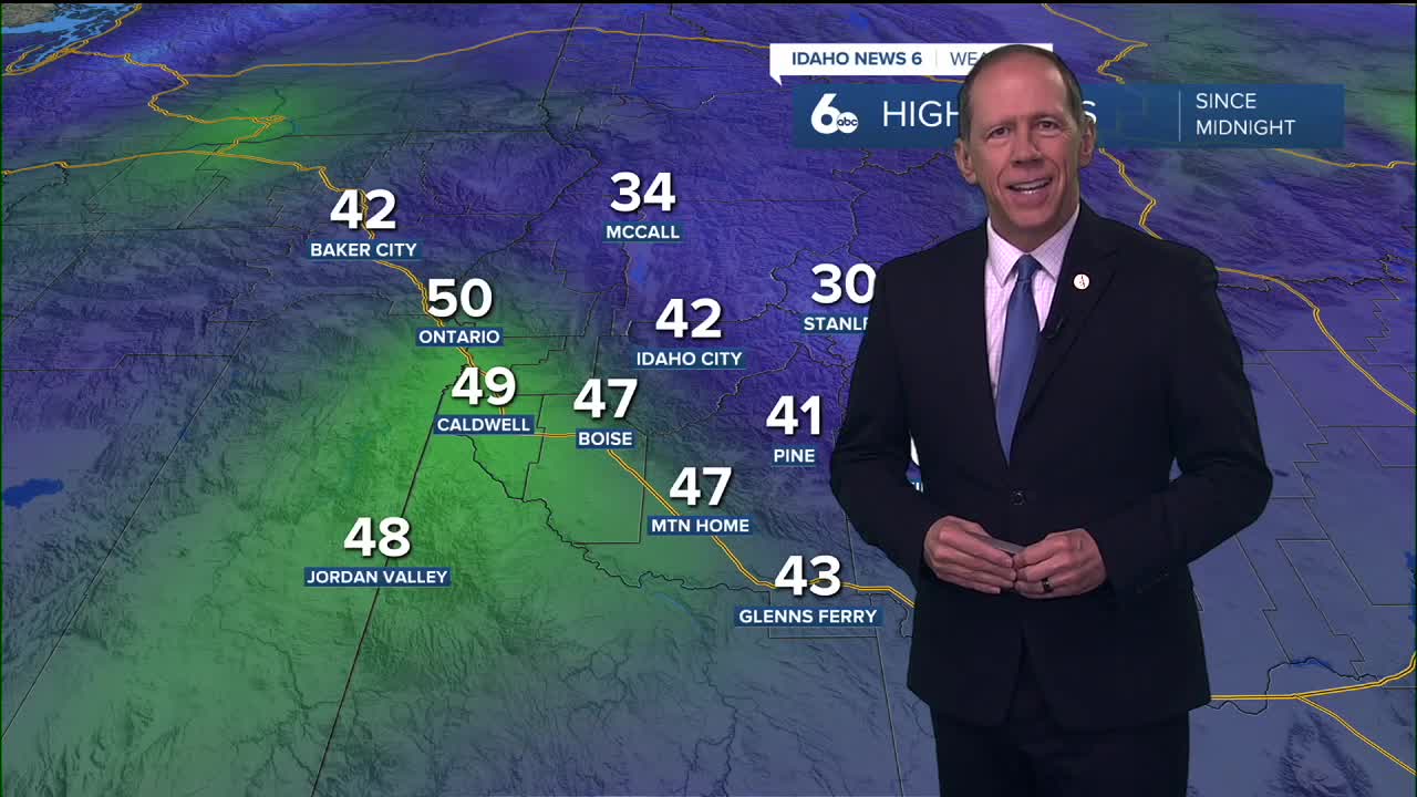
Mountain areas above 4,000 feet experienced 1 to 4 inches of snow accumulation overnight, while valley locations below 4,000 feet saw little to no snow accumulation from the storm system.
Blustery Thursday conditions ahead
Thursday will bring notably blustery and colder conditions, especially across valley areas. Northwest winds will gust throughout the day, creating wind chill effects that will make temperatures feel even colder than the forecast highs.
Valley locations can expect highs in the upper 30s with sustained northwest winds of 6 to 13 mph. The combination of cooler air and persistent winds will create uncomfortable conditions for outdoor activities and may impact travel, particularly for high-profile vehicles.
Mountain areas will see even colder conditions with highs in the mid-20s, making the wind chill factor particularly significant for anyone venturing into higher elevations.
Drying out pattern begins
High pressure will build over the region starting Friday night, bringing dry and stable conditions for the extended period. An inversion will develop over most valleys, creating stagnant air conditions and potential morning fog.
The ridge pattern will dominate through next week, keeping precipitation chances minimal except for a slight possibility in far northern areas late Monday through Tuesday. This marks a significant shift from the active winter weather pattern to prolonged dry conditions.
This story was reported on-air by a journalist and has been converted to this platform with the assistance of AI. Our editorial team verifies all reporting on all platforms for fairness and accuracy.
Day-by-day forecast
Wednesday Night: Rain and snow showers likely before 2 a.m., then a chance of snow. Thunder possible. Mostly cloudy with a low around 28 degrees. Light and variable wind becoming northwest 5 to 8 mph after midnight. Winds could gust as high as 21 mph. Chance of precipitation 70%. Little or no snow accumulation expected.
Thursday: Mostly sunny but blustery & colder with a high near 39 degrees and wind chill making it feel like 20s! NW wind 10-15 mph and gusty.
Thursday Night: Mostly cloudy and colder with a low around 27 degrees. Diminishing NW wind.
Friday: Mostly sunny with a high near 42 degrees. Light and variable wind.
Friday Night: Mostly clear with a low around 25 degrees.
Saturday: Mostly sunny with a high near 42 degrees.
Saturday Night: Partly cloudy with a low around 26 degrees.
Sunday: Partly sunny with a high near 43 degrees.
Sunday Night: Partly cloudy with a low around 26 degrees.
Monday: Mostly sunny with a high near 43 degrees.
Monday Night: Mostly cloudy with a low around 28 degrees.
Tuesday: Mostly sunny with a high near 45 degrees.
Tuesday Night: Partly cloudy with a low around 28 degrees.
Wednesday: Mostly sunny with a high near 47 degrees.
Stay connected right here for updates on our drying weather pattern.