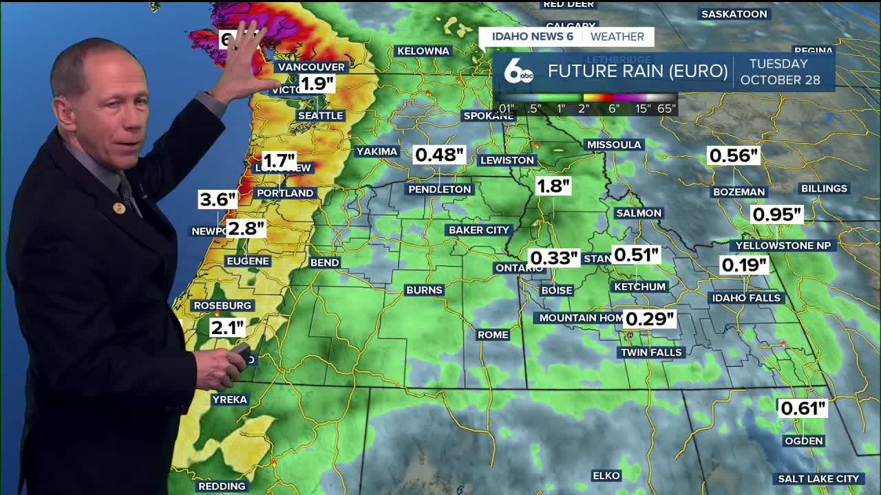


A significant weather pattern change is heading to Idaho this weekend, bringing the season's first substantial snowfall to the central mountains while the Treasure Valley experiences an appreciable rain event.
An atmospheric river event will impact the region from Friday night through Monday night, delivering widespread precipitation across southern Idaho. The National Weather Service forecasts snow levels starting around 7,000 to 8,000 feet during the heaviest precipitation Saturday, then dropping to 4,000 to 5,000 feet by Monday.
This will be a notable weather event for the areas as the system will bring 10 to 15-degree temperature drops behind a cold front moving through early Saturday morning.
Mountain travel impacts expected
The incoming storm system poses potential challenges for travel at elevations above 4,000 feet, particularly along mountain highways and passes in central Idaho. Drivers heading to higher elevation destinations should prepare for winter driving conditions beginning Saturday.
Areas above 4,000 feet could see accumulating snow late Saturday night through Monday as temperatures drop and snow levels lower. Mountain passes and higher elevation roadways may experience hazardous winter conditions with 8"-12" possible above 7000 feet. McCall could see up to 3" of snow Saturday and Sunday.
Ski areas prepare for season opener
Central Idaho ski areas are watching the forecast closely as this weather pattern could provide the first significant snowfall of the season. With snow levels dropping to 4,000 to 5,000 feet by Monday, mountains above that elevation should see accumulating snow.
The timing comes as ski resorts prepare for the upcoming winter season, with this storm potentially providing a foundation for early-season operations.
Valley stays mild with rain
The Treasure Valley will see pleasant conditions through Friday, with temperatures reaching near 70 degrees Friday afternoon - about 5 to 10 degrees above normal for late October. Sunny skies on Thursday will give way to increasing clouds on Friday as the system approaches.
Precipitation chances begin Friday night with a 20% chance of showers after midnight. Saturday brings an 80% chance of rain with temperatures dropping to the low 60s. The wet pattern continues through Monday with gradually decreasing precipitation chances.
Wind gusts will accompany the precipitation, with Friday seeing gusts up to 20 mph in the valley and stronger winds expected Saturday as the atmospheric river arrives.
Cooler temperatures arrive behind the front, with Monday night lows potentially dropping to 32 degrees.
The weather pattern shifts back toward drier conditions Tuesday and Wednesday, with partly sunny skies and temperatures returning to the 50s.
Daily forecast
Tonight: Partly cloudy, with a low around 39. Light and variable wind.
Thursday: Sunny, with a high near 64. Calm wind becoming northwest around 6 mph in the afternoon.
Friday: Mostly sunny, with a high near 70. Light east wind becoming south southeast 5 to 10 mph in the morning. Winds could gust as high as 20 mph.
Friday Night: Mostly cloudy, with a low around 52. SE wind 8-10 mph, with gusts as high as 24 mph.
Saturday: Showers. High near 63. Chance of precipitation is 80%. New precipitation amounts between a tenth and quarter of an inch possible.
Saturday Night: Showers likely, mainly before midnight. Mostly cloudy, with a low around 39. Chance of precipitation is 70%. New precipitation amounts between a tenth and quarter of an inch possible.
Sunday: Showers likely. Mostly cloudy, with a high near 52. Chance of precipitation is 70%.
Sunday Night: A 50% chance of showers. Mostly cloudy, with a low around 37.
Monday: A 40% chance of showers. Partly sunny, with a high near 50.
Tuesday: Mostly sunny, with a high near 53.
Wednesday: Partly sunny, with a high near 59.
Stay connected right here for updates to our weekend weather!