

Pleasant fall weather is on tap for the Treasure Valley this weekend as a "dirty ridge" (meaning some clouds drifting through) builds into the area, bringing the mildest temperatures in over a week and ideal conditions for outdoor activities.
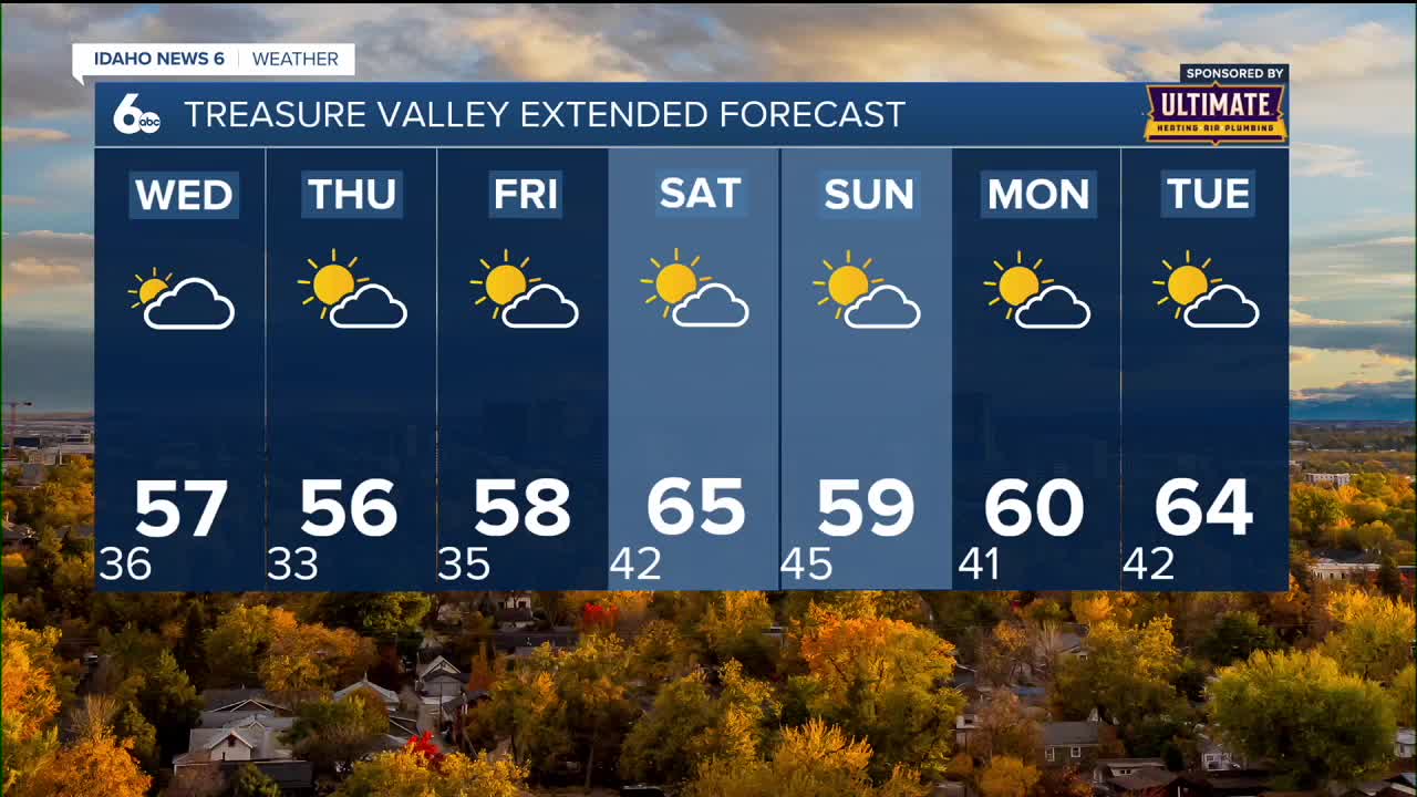
Saturday looks particularly appealing with mostly sunny skies and highs reaching 65 degrees - about 10 degrees above normal for late October. The warming trend begins Friday with temperatures climbing to 58 degrees under mostly sunny conditions.
The mild weather comes as high pressure dominates the regional weather pattern, ensuring dry conditions through most of the weekend.
Perfect weekend conditions
Saturday stands out as the pick day of the weekend with abundant sunshine and the warmest temperatures of the week. The 65-degree high will make it feel more like early October than late in the month.
Friday kicks off the pleasant pattern with mostly sunny skies and highs near 58 degrees. While not as warm as Saturday, it will still represent a noticeable improvement from the recent below-normal temperatures.
Sunday remains pleasant though slightly cooler, with partly sunny skies and highs near 59 degrees. A weak weather system may bring a 20% chance of showers Saturday night, but any precipitation looks light and brief.
Dry pattern continues midweek
The current dry weather pattern will persist through Thursday as ridging aloft remains in place. Wednesday will see increasing clouds as an upper-level wave tracks across eastern Washington and the Idaho panhandle.
A sprinkle or mountain flurry is possible north of McCall Wednesday, but otherwise conditions remain dry across the Treasure Valley and central Idaho. The ridge quickly rebounds Thursday, bringing mostly sunny skies with highs near 56 degrees.
Breezy easterly winds will continue through Wednesday morning before relaxing and shifting to the northwest in the afternoon. Temperatures will remain at or slightly below normal through Thursday before the weekend warming begins.
Extended mild pattern
The pleasant weather extends well into next week, with temperatures remaining 5 to 10 degrees above normal through Tuesday. Monday looks mostly sunny with highs around 60 degrees, followed by partly sunny skies and 64-degree temperatures Tuesday.
A deep upper-level trough in the Gulf of Alaska will help maintain the mild pattern as it keeps the jet stream well to the north. This setup typically brings stable, warm conditions to southern Idaho during late October.
The only weather concern appears Sunday into Monday when increasing rain chances develop across the Blue Mountains in Oregon and west-central Idaho mountains. However, the Treasure Valley should remain largely dry during this period.

Mountain weather notes
While the valley enjoys mild conditions, mountain areas may see some light precipitation Wednesday as the upper-level wave passes through. Any snow would be limited to elevations well above typical travel routes.
The weekend's mild temperatures will extend into mountain areas as well, making it an excellent time for hiking and outdoor recreation at higher elevations. Clear skies Saturday will provide excellent visibility for mountain activities.
Mountain fog that developed earlier this week should dissipate as the weather pattern becomes more active and winds increase.

Daily forecast
Tonight: Partly cloudy, with a low around 36. Southeast wind 6 to 9 mph.
Wednesday: Mostly cloudy, then gradual clearing during the afternoon, with a high near 57. Wind NW 6-10 in the afternoon.
Wednesday Night: Mostly clear, with a low around 33. Wind becoming calm.
Thursday: Mostly sunny, with a high near 56. Calm wind.
Friday: Mostly sunny, with a high near 58.

Saturday: Mostly sunny, milder & pleasant, with a high near 65.
Sunday: Partly sunny, with a high near 59.
Monday: Mostly sunny, with a high near 60.
Tuesday: Partly sunny & milder, with a high near 64.
Stay connected right here for updates to my extended forecast for the weekend.