

Unseasonably mild temperatures will continue through the holiday as a warm front has moved well north of the region, bringing temperatures 15 to 20 degrees above seasonal normals along with increasing rain chances and strong winds.
Current Pattern: Warm Front Brings Exceptional Mildness
A warm front has positioned itself well north of Baker City and McCall, allowing mild temperatures and drier conditions to dominate the area. This pattern is producing temperatures that are running 15 to 20 degrees above seasonal normals, creating exceptionally warm conditions for late December.
Clearing across portions of southwestern Idaho early this evening as the region settles into the warm sector of this weather system.

Wind Advisory: Strong Pressure Gradient Develops
A strong pressure gradient will develop across southern Oregon and southern Idaho, bringing strong southerly winds to the highlands of southern Idaho near the Nevada border and to portions of Harney and Malheur counties in southern Oregon, where a wind advisory has been issued.
These strong winds will be most pronounced in elevated areas, with gusts potentially reaching advisory criteria levels before conditions moderate later in the week.
Holiday Weather: Rain Returns with Continued Warmth
The mild weather pattern will persist through the holiday, though clouds and precipitation chances will increase as the next weather system approaches. Rain will become likely across much of the area, with the central Idaho mountains seeing the highest precipitation chances due to orographic enhancement.
Snow levels will remain exceptionally high, staying above 7,000 feet through the holiday period, which will keep most precipitation falling as rain rather than snow across the region.
Travel weather will be free of snow up to 6000 feet through Thursday, with snow levels lowering on Friday to 4500 feet. So the only issues will be during the dark hours on Thursday night and Friday above 4500 feet.
The Blue Mountains will have no snow except a slight chance on Friday morning.

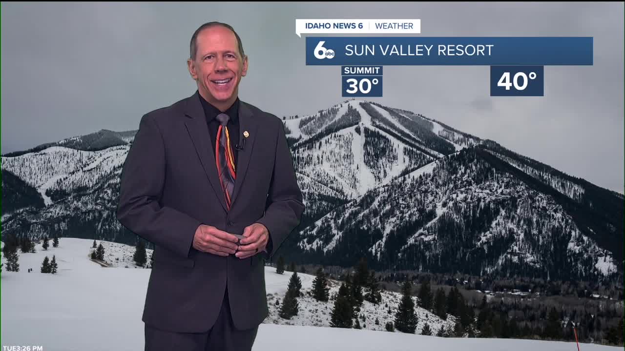
Mountain Snow Conditions for Ski Areas
The continued mild weather pattern presents challenging conditions for winter recreation. Snow levels remaining well above 7,000 feet mean that even high-elevation ski resorts may experience rain at base elevations. Only the very highest peaks above 7,000 feet will receive any new snowfall, and amounts will be minimal due to the persistent warm air mass.
This pattern is particularly unusual for late December and continues to impact the winter recreation industry across Idaho's mountain areas.
That being said, Sun Valley's Bald Mountain will get hit hard with 18"-30 inches of snow from Wednesday through Friday, with the most snow closer to the summit! Ketchum could get several inches of snow Thursday night through Friday.

Extended Outlook: Gradual Return to Seasonal Conditions
The weather pattern will begin transitioning after the holiday, with a gradual cooling trend expected through the weekend. Rain chances will continue into Friday before conditions become drier and more seasonal.
The weekend will mark a return to more typical late December weather, with mostly sunny skies and temperatures gradually dropping closer to normal ranges. This transition will bring relief from the unseasonably warm conditions that have dominated the region.

Daily Forecast:
Tonight: Mostly cloudy, with a low around 46. ESE wind 6 to 10 mph, with gusts as high as 21 mph.
Wednesday: Rain, mainly after 11 a.m. High near 57. ESEt wind 10 to 15 mph, with gusts as high as 26 mph. Chance of precipitation is 80%.
Wednesday Night: Rain. Low around 42. ESEt wind 6 to 8 mph. Chance of precipitation is 90%. New precipitation amounts between a tenth and quarter of an inch possible.
Thursday: A 50% chance of rain. Partly sunny, with a high near 57. SE wind 6 to 11 mph, with gusts as high as 21 mph.
Thursday Night: Rain. Low around 39. SE wind 6 to 8 mph. Chance of precipitation is 80%.
Friday: Rain likely, mainly before 11 a.m. Mostly cloudy, with a high near 49. Chance of precipitation is 70%.
Friday Night: A chance of rain before 11 p.m. Partly cloudy, with a low around 31. Chance of precipitation is 40%.

Saturday: Mostly sunny, with a high near 42.
Saturday Night: Mostly clear, with a low around 25.
Sunday: Mostly sunny, with a high near 40.
Sunday Night: Partly cloudy, with a low around 25.
Monday: Mostly sunny, with a high near 42.
Monday Night: Partly cloudy, with a low around 26.
Tuesday: Mostly sunny, with a high near 43.
Stay connected right here for updates to my forecast!