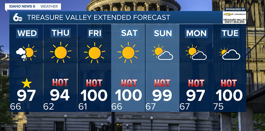
Southern Idaho will once again have a chance of isolated to scattered thunderstorms this afternoon and evening as moisture lingers across the region. The greatest chances for storm development will be over the higher terrain south of the Snake River, with storms tracking northeast through portions of the Magic Valley and southern Boise Mountains.
The main concerns with any thunderstorm today will be strong outflow winds, frequent lightning, and localized blowing dust. Wind gusts between 40 and 60 mph are possible near stronger storms, while brief heavy rainfall could occur in isolated locations. While most storms are expected to stay east of the Boise Metro, gusty outflow winds could still reach the Treasure Valley later this afternoon and evening.
F
A Red Flag Warning is in effect from 1 PM to 8 PM today due to elevated fire weather concerns. Scattered thunderstorms are expected to develop this afternoon and evening, bringing the potential for lightning strikes on hot, dry fuels. Combined with gusty outflow winds, any new fire starts could spread quickly. Avoid activities that could spark a fire, and stay weather-aware throughout the day.
Outside of the storm threat, temperatures will remain hot across the region. Highs will climb into the mid to upper 90s across the lower elevations, while mountain communities reach the 80s and lower 90s.

A weak dry cold front will move through the area later today, bringing widespread northwest wind gusts of 20 to 35 mph. Breezy conditions will continue through Thursday, especially across southern Idaho. Combined with hot temperatures and dry vegetation, elevated fire weather concerns will persist.
Residents are encouraged to avoid activities that could spark a fire. Thursday will be slightly cooler, with temperatures dropping a few degrees, but the cooldown will be short-lived.
A strengthening ridge of high pressure will build into the western United States on Friday, sending temperatures back upward. Many lower valley communities will approach 100 degrees, and Boise has roughly a 50 to 60 percent chance of reaching triple digits for the first time this year.
Looking ahead to the weekend, hot and mostly dry conditions will continue, with highs near 100 degrees on Saturday. Early next week, monsoonal moisture is expected to return to the region, bringing renewed chances for showers and thunderstorms. The added moisture could increase the risk of heavy rainfall, flash flooding near burn scars, and new wildfire starts from lightning strikes.