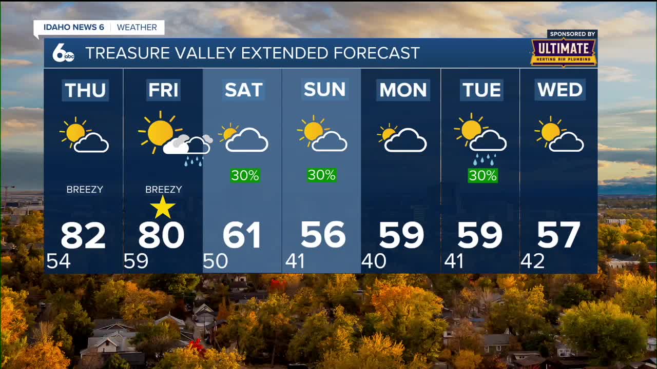


Gusty southeast winds have helped boost temperatures well into the 70s in the valley, and those highs will get even warmer on Thursday and Friday as pleasant conditions continue across southwest Idaho.
Peak warmth arrives Thursday and Friday
Thursday and Friday will bring the warmest temperatures of the week, with highs in the valleys reaching around 81 degrees both days. Sunny skies and light winds will make for ideal outdoor conditions before changes arrive this weekend.
The gusty southeast winds that helped warm temperatures will continue to play a role, becoming gusty at times both days.
Weekend weather system approaches
By Friday, a weather system will organize into a closed low off the Oregon coast. Southwest Idaho will remain mostly quiet throughout Friday, but a cold front is expected to move in Friday evening.
Showers will spread in late Friday night, with a 20 to 40% chance in the valleys and much higher odds in the mountains. West-central Idaho and the Boise Mountains have a 60 to 80% chance thanks to upslope winds feeding moisture into the terrain.

Cooler, wetter weekend ahead
Looking into the weekend, Saturday brings cooler, wetter conditions with valley rain chances around 40% although much of the time the valleys will not see any rain. Mountain coverage remaining near 60 to 80%. Behind the front, winds will turn west-northwest with gusts between 15 to 25 mph Saturday afternoon.
Temperatures will tumble 10 to 20 degrees on Saturday and drop another 5 to 10 degrees by Sunday. Saturday's high will only reach around 63 degrees - a dramatic change from the 81-degree weather earlier in the week.

Extended outlook into next week
Sunday will see partly sunny skies with a 30% chance of morning showers and highs around 56 degrees. The unsettled pattern continues into Monday and beyond, with daily shower chances around 30% and temperatures remaining in the upper 50s to low 60s.

Daily forecast
Tonight: Increasing clouds, with a low around 53. Southeast wind 5 to 9 mph becoming calm after midnight.
Thursday: Sunny, with a high near 81. East southeast wind 7 to 9 mph.

Friday: Sunny, with a high near 81. East southeast wind 8 to 10 mph.
Friday Night: A slight chance of showers and thunderstorms, then a chance of showers after midnight. Partly cloudy, with a low around 50. South southwest wind around 6 mph becoming light and variable in the evening. Chance of precipitation is 30%.
Saturday: A 20% chance of showers before noon. Mostly sunny, with a high near 63.
Saturday Night: A 40% chance of showers. Mostly cloudy, with a low around 42.
Sunday: A 30% chance of showers before noon. Partly sunny, with a high near 56.
Sunday Night: A 20% chance of showers after midnight. Mostly cloudy, with a low around 42.
Monday: A 30% chance of showers, mainly before noon. Partly sunny, with a high near 61.
Tuesday: A 30% chance of showers. Partly sunny, with a high near 59.
Wednesday: A 30% chance of showers. Patchy fog. Otherwise, partly sunny, with a high near 55.
Stay connected right here and to my Facebook Page for updates to my ScottScore extended forecast.