

High clouds are filtering across the Treasure Valley Monday, bringing overcast skies to much of the region as a ridge of high pressure continues building overhead. This marks a return to cloudier conditions after the weekend's clear skies that followed the breakdown of the persistent temperature inversion.
Temperatures will remain near to slightly below normal through Tuesday night, with dry conditions prevailing as the high-pressure system strengthens its grip on the region.
Brief weather system Wednesday
A quick-hitting cold front will move through the region early Wednesday morning, bringing breezy westerly winds and the potential for light precipitation. The system will produce snow at high elevations with valley rain, though showers will be brief with minimal accumulation anticipated.
Current forecasts show the Treasure Valley with only a 5 to 15% chance of a shower between 5 and 10 a.m. Wednesday, but forecast confidence remains low due to persistent dry air at the surface.
Snow possible in valleys
If precipitation does develop, it is likely to fall as snow in the valleys due to overnight cold temperatures paired with colder air lingering from the recent inversion pattern. Any snow accumulations appear minimal, with less than one inch expected even at higher elevations.
The front and associated precipitation will move out by late Wednesday afternoon as stagnant conditions return with the rebuilding ridge of high pressure.
Ridge dominance continues
An upper-level ridge will dominate much of the West through the extended forecast period. While the main storm track will remain north of the forecast area, several minor shortwave troughs passing over the top of the ridge will temporarily weaken the upper-level pattern.
Multiple precipitation chances
The first wave will pass through the area Friday, bringing a 30 to 50% chance of precipitation to the region. This represents the best chance for meaningful moisture in the coming week.
A second wave is expected Sunday and Monday, bringing a 20 to 30% chance of precipitation to the area, though this system appears weaker than Friday's potential.
Warming trend ahead
Temperatures will see a gradual warming trend, reaching 5 to 10 degrees above normal by late in the forecast period. This warming will be most pronounced at higher elevations as the ridge strengthens.
Stagnation concerns return
Forecasters will be monitoring for stagnant conditions possibly returning during the extended forecast period as the ridge rebuilds and strengthens over the region.
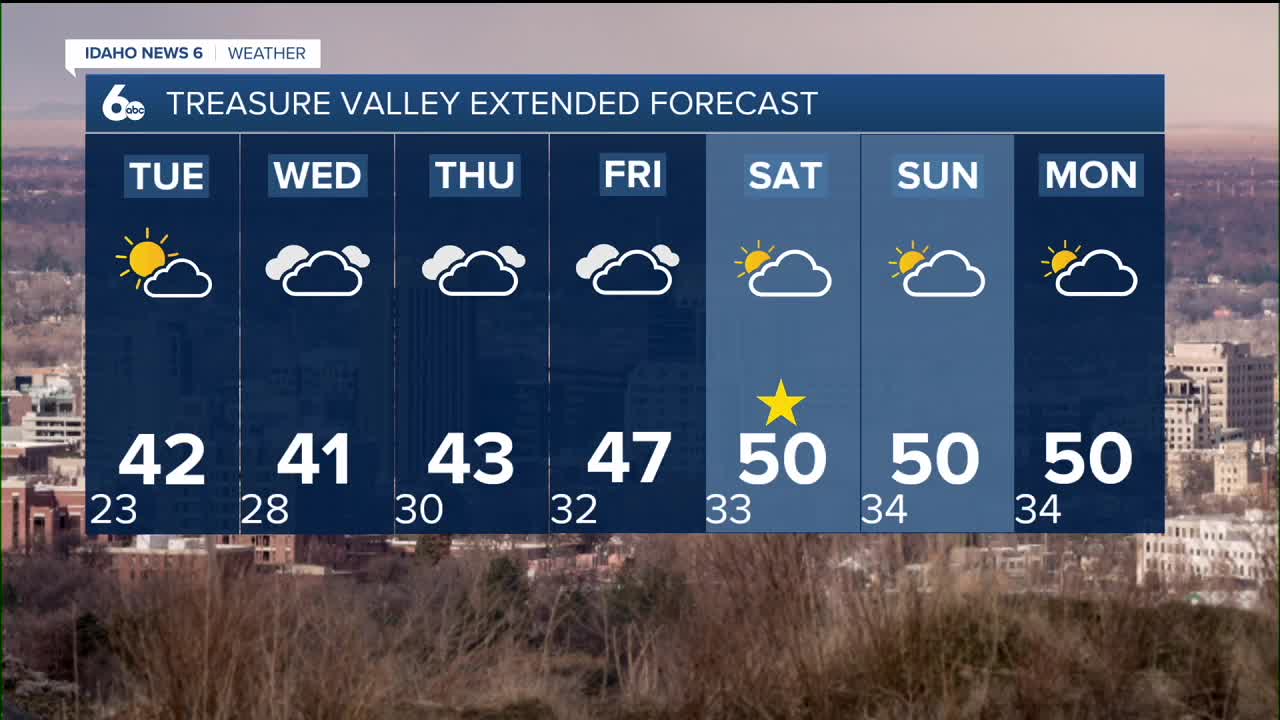
Daily forecast breakdown
Monday night Cloudy during the early evening, then gradual clearing with a low around 22 degrees. Calm winds.
Tuesday Increasing clouds with a high near 42 degrees. Light and variable winds.
Tuesday night Mostly cloudy skies with a low around 28 degrees. light wind.
Wednesday A slight chance of rain and snow showers before 11 a.m. Mostly cloudy with a high near 40 degrees. Calm winds. Chance of precipitation is 20%.
Wednesday night Mostly cloudy conditions with a low around 30 degrees. Calm winds.
Thursday Mostly cloudy skies with a high near 43 degrees as the ridge rebuilds.
Thursday night Mostly cloudy conditions with a low around 32 degrees.
Friday A 20% chance of showers after 11 a.m. Cloudy and milder with a high near 47 degrees as the first shortwave approaches.
Friday night Mostly cloudy skies with a low around 33 degrees.
Saturday Mostly cloudy conditions & unseasonably mild with a high near 50 degrees as temperatures begin climbing above normal.
Saturday night Mostly cloudy skies with a low around 34 degrees.
Sunday Mostly cloudy conditions & unseasonably mild with a high near 50 degrees as the second wave approaches.
Sunday night A 20% chance of showers. Mostly cloudy with a low around 34 degrees.
Monday Partly sunny skies & continued mild with a high near 50 degrees as conditions improve temporarily.
Stay connected right here for updates on my extended forecast.