

A significant weather pattern is developing across the Pacific Northwest, bringing a mix of precipitation types and changing conditions over the next several days. The region is experiencing the effects of a frontal system that will impact travel and daily activities into Thursday.
Current weather situation
Mountain areas in northeastern Oregon and central Idaho are currently experiencing widespread precipitation as a frontal system moves through the region. The Snake River Basin and eastern Oregon valleys have remained dry but will see conditions change as the weather system progresses.
A cold front is approaching the area, which will bring notable changes to precipitation types and temperatures. Snow levels will drop significantly during the overnight hours, creating potential impacts for both mountain and valley locations.
Wednesday weather developments
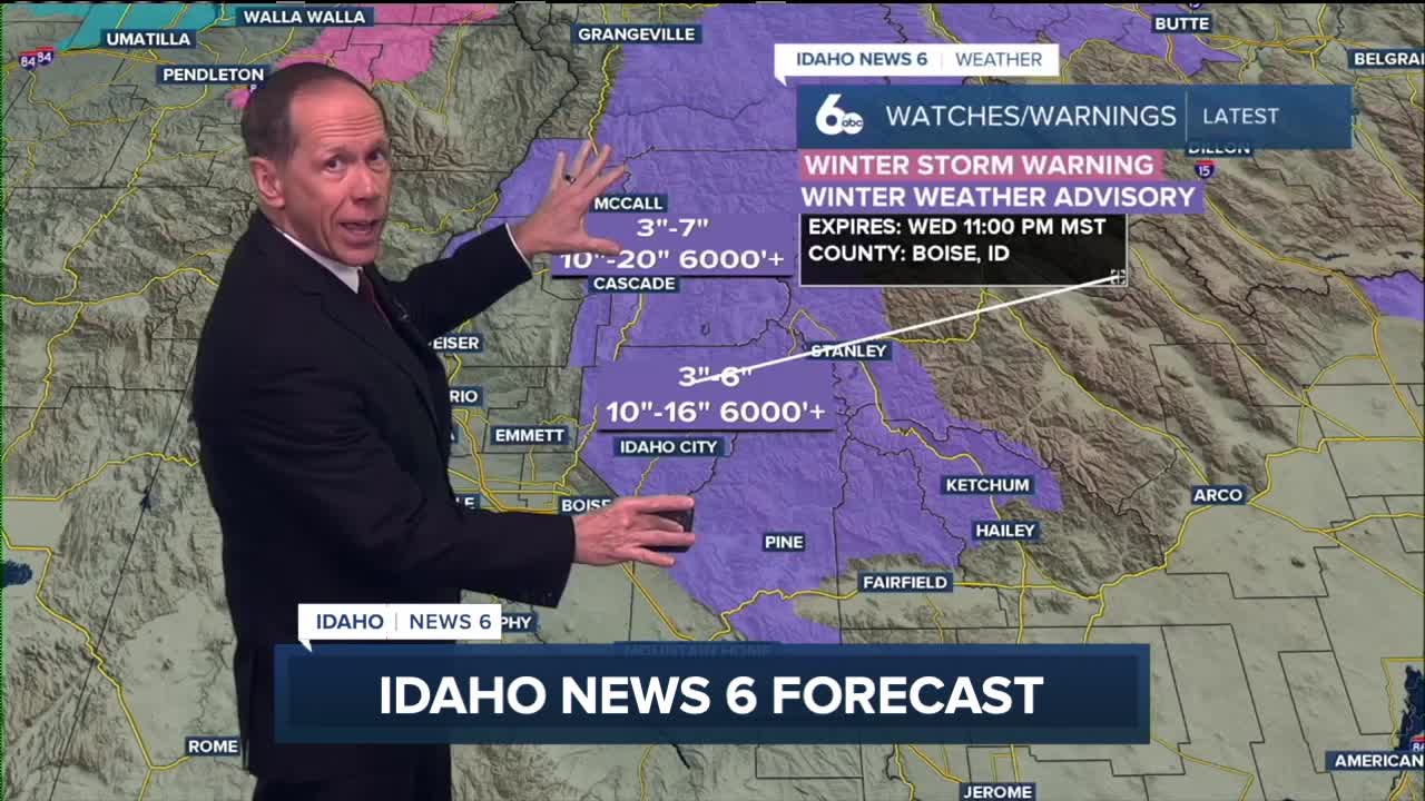
The most active weather is expected Tuesday night and Wednesday as multiple weather features interact over the region. A shortwave disturbance is tracking into western Idaho at this hour.
This weather pattern will create unstable atmospheric conditions, leading to the possibility of moderate to heavy snow showers. Graupel and thunderstorms may also develop as cold air moves overhead, creating dramatic weather conditions for the region.
Mountain areas above 5,000 feet elevation face the highest snow accumulation potential, while lower valleys may see lighter amounts. The variable nature of snow showers means accumulations will differ significantly across short distances.
Extended outlook
Following Thursday's weather activity, a high-pressure ridge will build over the region, bringing significant changes to the weather pattern. This ridge will dominate conditions for several days, creating dry and stable atmospheric conditions.
The high-pressure system will support the development of temperature inversions, particularly in valley locations. These inversions often lead to fog and low cloud formation that can persist for multiple days, reducing visibility and creating cooler surface temperatures.
Weekend conditions will remain under the influence of the ridge, though some weakening is possible Sunday. This could allow moisture to return to northern portions of the forecast area, though any precipitation chances remain limited.
This story was reported on-air by a journalist and has been converted to this platform with the assistance of AI. Our editorial team verifies all reporting on all platforms for fairness and accuracy.
Day-by-day forecast
Tuesday Night: Rain likely with cloudy skies. Low around 38 degrees. Light wind. Chance of precipitation 70%.
Wednesday: Rain likely before 2 p.m., then rain and snow showers likely. Thunder possible. Mostly cloudy with a high near 47 degrees. Calm wind becoming west northwest 5 to 7 mph in the morning. Chance of precipitation 70%. Little or no snow accumulation expected.
Wednesday Night: Snow showers with thunder possible! Low around 28 degrees. Light NW breeze developing. Chance of precipitation 60%. New snow accumulation less than half an inch possible.
Thursday: Mostly sunny, blustery & colder with a few flurries and a high near 39 degrees. Gusty NW winds 10-18 with gusts to 25 mph.
Thursday Night: Mostly cloudy with a low around 26 degrees.
Friday: Mostly sunny with a high near 41 degrees.
Friday Night: Mostly clear with a low around 24 degrees.
Saturday: Mostly sunny with a high near 42 degrees.
Saturday Night: Mostly cloudy with a low around 27 degrees.
Sunday: Partly sunny with a high near 43 degrees.
Sunday Night: Partly cloudy with a low around 26 degrees.
Monday: Mostly sunny with a high near 43 degrees.
Monday Night: Partly cloudy with a low around 27 degrees.
Tuesday: Mostly sunny with a high near 44 degrees.