

Western Idaho's persistent stagnant weather pattern is intensifying, prompting officials to issue a Dense Fog Advisory for the Lower Treasure Valley. The strengthening high pressure ridge is deepening valley inversions and trapping both cold air and pollutants near the surface.
Dense fog advisory in effect
A Dense Fog Advisory has been issued for the Lower Treasure Valley from late tonight through Wednesday morning as high-resolution weather models indicate a higher probability of dense fog redeveloping. The strengthening inversion pattern is creating ideal conditions for thick fog formation that will significantly reduce visibility.
Confidence in dense fog reaching Boise Wednesday morning stands at around 30%, while patchy fog is expected across the Upper Treasure Valley, Western Magic Valley, and sheltered mountain valleys. Areas caught in the fog will experience very little temperature variation throughout the day.
Persistent fog challenges
The fog and low clouds will be particularly difficult to dissipate, especially in the Lower Treasure Valley and Long Valley on Wednesday. The strengthening ridge pattern means fog will likely return across much of the Snake River Plain and sheltered valleys Wednesday night into Thursday.
Weather models have struggled to accurately capture the cold air trapped within these inversions, making precise fog forecasting challenging. However, the overall pattern strongly favors continued fog development in valley locations.
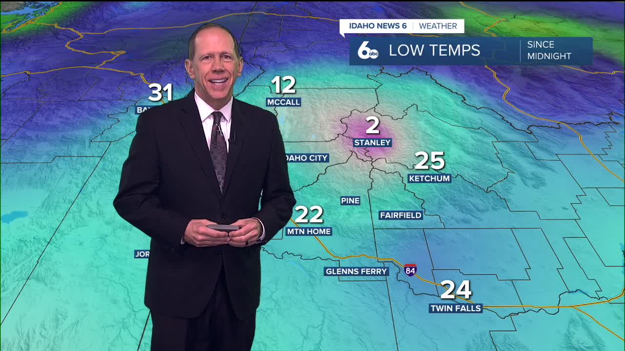
Temperature inversions deepen
As the upper-level ridge strengthens, valley inversions will continue deepening, creating stark temperature contrasts across the region. Valley locations will see highs near or slightly below normal, while mountain areas experience temperatures 5 to 10 degrees above normal.
This inverted temperature pattern traps cold air and pollutants near the surface in valleys while allowing unseasonably warm conditions at higher elevations. The result is dramatically different weather conditions within short distances.
Extended stagnant outlook
Weather models continue pointing toward a high-amplitude ridge over the Western United States with little relief in sight through the extended forecast. Air stagnation and fog will remain the primary weather story, with higher elevations continuing to see warmer temperatures than lower mountain valleys.
The first signs of relief from stagnant conditions may come late next Wednesday, when an upper-level trough could bring chances of precipitation and increased atmospheric mixing. Weather models show good agreement on the ridge pattern breaking down by the end of next week.
Day-by-day forecast
Tuesday Night: Widespread fog, mainly after 2 a.m. Otherwise, partly cloudy with a low around 28 degrees. Calm wind.
Wednesday: Areas of fog before 11 a.m. Otherwise, sunny with a high near 44 degrees. Calm wind.
Wednesday Night: Patchy fog after 10 p.m. Otherwise, mostly clear with a low around 25 degrees. Calm wind.
Thursday: Widespread fog before 11 a.m. Otherwise, sunny with a high near 43 degrees. Calm wind.
Thursday Night: Patchy fog after 8 p.m. Otherwise, mostly clear with a low around 25 degrees. Calm wind.
Friday: Sunny with a high near 43 degrees.
Friday Night: Mostly clear with a low around 26 degrees.
Saturday: Sunny with a high near 44 degrees.
Saturday Night: Clear with a low around 26 degrees.
Sunday: Sunny with a high near 43 degrees.
Sunday Night: Mostly clear with a low around 27 degrees.
Monday: Sunny with a high near 44 degrees.
Monday Night: Partly cloudy with a low around 28 degrees.
Tuesday: Mostly sunny with a high near 43 degrees.