

A cold front moved through Idaho Friday afternoon, clearing persistent fog from lower valleys with breezy west to northwest winds, while setting the stage for the season's first snowfall in valley locations Sunday morning.
Friday Afternoon: Wind and Clearing Conditions
The cold front brought the strongest winds to the Magic Valley, with gusts reaching 35 to 40 mph Friday afternoon. Any lingering showers from the system will taper off this afternoon as the front continues moving eastward.
The breezy conditions have successfully mixed out the fog that had been plaguing lower valleys, providing much-improved visibility and air quality across the region.
Tonight Through Saturday: Fog Returns Before Next System
Fog is forecast to redevelop in valleys tonight into Saturday morning, with the best chances along the foothills in the Boise metro area, extending to the Magic Valley, Baker Valley and around Burns, Oregon.
Saturday will see patchy fog before 8 a.m., then mostly cloudy skies with a high near 45 degrees. Light southeast winds will become south-southeast at 5 to 10 mph in the morning, with gusts potentially reaching 28 mph.
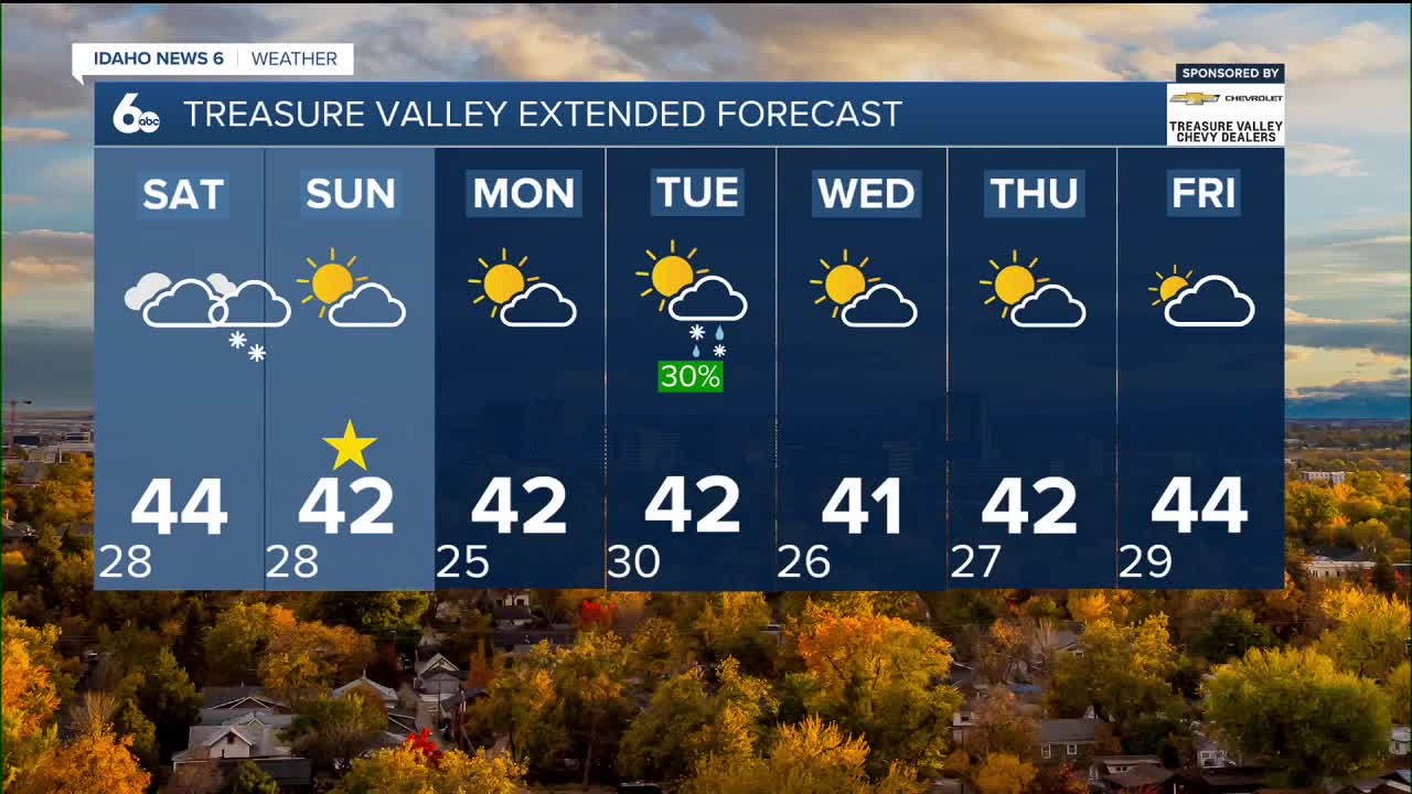
Sunday Morning: First Valley Snow of the Season
Another system and cold front will arrive late Saturday night into Sunday morning, bringing the potential for the first snow of the season to many valley locations. A dusting of snow is possible Sunday morning, marking a significant weather milestone for the region.
Snow accumulations will generally be under an inch in the valleys, with 1 to 3 inches expected in the mountains. The light snowfall may create picturesque winter scenes but is not expected to cause significant travel impacts.
Precipitation will taper off midday Sunday, followed by breezy northwest winds during the afternoon and partial clearing. Sunday's high will reach near 42 degrees.
Mountain Snow Conditions for Ski Areas
The weekend system will provide beneficial snowfall for Idaho's ski areas, with 1 to 3 inches of new snow expected in the mountains. This early season accumulation will help build base depths at higher elevation resorts. While valley locations may only see a dusting, mountain passes could experience light accumulations that may affect travel conditions Sunday morning.
Extended Outlook: Active Pattern Continues
North-northwesterly flow aloft Monday will keep temperatures seasonal through the long term. The position of the jet stream overhead will carry a couple of shortwave troughs through the area during the week.
The first system arrives Tuesday and Wednesday with precipitation chances of 20 to 40% in lower elevations and 60 to 70% in high elevations. Rainfall amounts of a trace to 0.03 inches are forecast for lower elevations, with up to 0.2 inches possible in higher elevations.
With snow levels at 3,000 to 4,000 feet, locations above that elevation will see 0 to 2 inches of snow during the Tuesday-Wednesday system.
Weather models show some uncertainty for late next week, with solutions ranging from continued dry conditions to more active weather Friday and Saturday, depending on how upper-level patterns evolve.
Daily Forecast:
Tonight: Patchy fog after 11 p.m. Otherwise, increasing clouds, with a low around 28. Northwest wind around 6 mph becoming calm in the evening.
Saturday: Patchy fog before 8 a.m. Otherwise, mostly cloudy & blustery, with a high near 45. Wind NW 5-15 with higher gusts later in the day.
Saturday Night: A 30% chance of snow after 11 p.m. Mostly cloudy, with a low around 28. Light wind. New snow accumulation of less than a half inch possible.
Sunday: Mostly sunny, with a high near 42. Light wind.
Sunday Night: Mostly clear, with a low around 25.
Monday: Mostly sunny, with a high near 42.
Monday Night: A slight chance of rain and snow after 11 p.m. Mostly cloudy, with a low around 30. Chance of precipitation is 20%.
Tuesday: A chance of rain and snow before 11 a.m. Partly sunny, with a high near 43. Chance of precipitation is 30%.
Tuesday Night: Patchy fog after 5 a.m. Otherwise, partly cloudy, with a low around 26.
Wednesday: Patchy fog. Otherwise, mostly sunny, with a high near 42.
Wednesday Night: Partly cloudy, with a low around 26.
Thursday: Partly sunny, with a high near 42.
Stay connected right here for updates to our weekend weather!