



A major weather change arrives this weekend as a strong cold front sweeps through Idaho, dropping temperatures and setting up an unsettled stretch that could continue into early next week.
The biggest story may not simply be the cooler temperatures. It will be the dramatic difference in rainfall from west to east.
Much cooler temperatures across the region is Scott Dorval's video forecast
Much Drier in the Western Valleys
For communities around the Treasure Valley and into eastern Oregon, this does not look like a weekend washout.
Saturday should actually feature a good amount of dry weather in the western valleys. After a breezy Friday evening, temperatures fall sharply behind the cold front. Saturday's high in Boise is expected to reach only around 61 degrees.
A few showers become possible Saturday night, with another chance Sunday afternoon and Sunday night. Even then, rainfall around the western valleys should be considerably lighter than what is expected farther east.
That is because the deepest moisture associated with the remnants of Tropical Storm Rachel is expected to stay mainly south and east of the Treasure Valley.
Soaking Rain Becomes More Likely Farther East
Travel east, and the forecast becomes much wetter.
The Boise Mountains and especially the eastern Magic Valley have a better opportunity for meaningful precipitation through the weekend. Southcentral and southeastern Idaho could receive significant rainfall late Saturday into early next week.
The western Magic Valley continues to have a 55% to 65% chance of receiving at least another tenth of an inch of rain between Monday morning and Tuesday morning, according to the Boise forecast discussion supplied Friday afternoon.
The slow-moving upper-level storm will keep precipitation chances around through Tuesday, particularly across the western Magic Valley, Boise Mountains and Southern Idaho Highlands.
So while Boise and many western communities may be asking,"Where's all the rain?", places farther east could be dealing with a much wetter and longer-lasting weather event.

Mountain Snow Returns
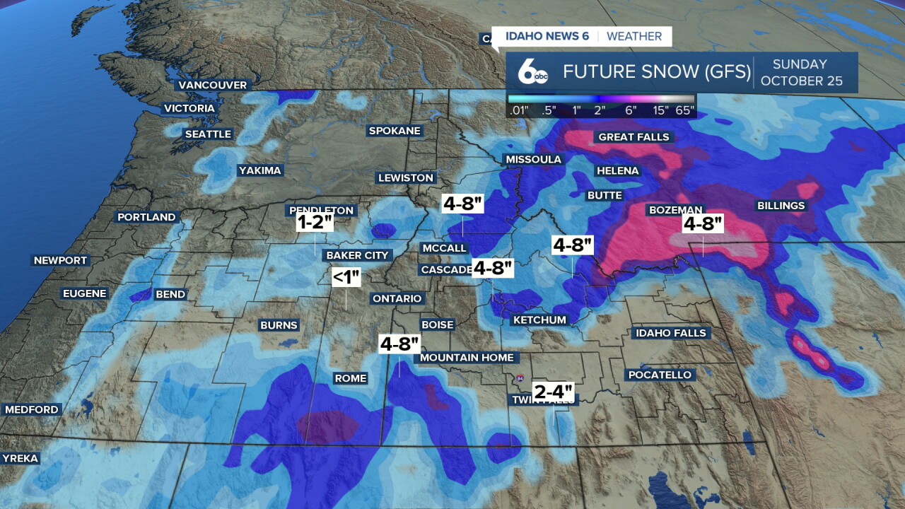
The colder air will also bring snow back to the high country.
Snow levels could fall to around 5,000 to 6,000 feet across parts of eastern Oregon and north of McCall, although precipitation there will be limited.
Across the central Idaho mountains, snow levels should generally remain higher, around 7,000 to 8,000 feet, during the wetter portion of the storm.
Little accumulation is expected below the higher elevations.
Cooler Through Early Next Week
Sunday looks cooler, with highs only in the middle 50s around Boise and a chance of afternoon showers.
Showers remain possible on Columbus Day with temperatures again struggling through the 50s.
By Tuesday, the pattern finally begins to change. Sunshine should become more common with highs rebounding into the lower 60s.
Then comes another sizeable turnaround.
High pressure is expected to build across the West during the second half of next week, sending temperatures back upward. Boise could reach the mid-60s Wednesday, upper 60s Thursday and around 71 degrees Friday.
In other words, we go from a fall-like weekend back toward noticeably warmer weather by the end of next week.
Major Hurricane Approaching the Gulf Coast. While Idaho deals with a dramatic fall weather change, a far more dangerous storm is approaching the Gulf Coast.
Hurricane Isaias was a Category 3 major hurricane Friday afternoon with maximum sustained winds of 115 mph, according to the 4 p.m. CDT National Hurricane Center update. The hurricane was moving north at 17 mph toward the northern Gulf Coast.
Landfall is expected Friday night near the Alabama-Florida border region. Tropical-storm conditions were already spreading onto the northern Gulf Coast during the afternoon.
The threats extend well beyond the hurricane's winds. The National Hurricane Center was warning of dangerous storm surge, while heavy rain, flash flooding and tornadoes are also concerns as the system moves inland. One Friday afternoon report indicated 6 to 9 feet of storm surge could occur from the Alabama-Florida border to Grayton Beach, Florida, if the peak coincides with high tide.
There is also an interesting connection to our weather in the West, although it involves a different tropical system. The moisture mentioned in the Boise forecast is associated with Tropical Storm Rachel in the eastern Pacific, not Hurricane Isaias in the Gulf. The National Hurricane Center was issuing advisories for both storms Friday afternoon.

Tonight
Mostly cloudy, with a low around 47. Light NW breeze.
Saturday
Mostly sunny, a breezy and much cooler, with a high near 61. WNW wind 10-15 mph, with gusts as high as 20 mph.
Saturday Night
A 30 percent chance of showers, mainly before 10pm. Mostly cloudy, with a low around 40. WNW wind 6 to 9 mph.
Sunday
Partly sunny & chilly with a 40% chance of showers especially later in the day, with a high near 56. A NW breeze 5-10.
Sunday Night
A 50 percent chance of showers. Mostly cloudy, with a low around 39. A NW breeze 5-10.
Columbus Day
Mostly cloudy with showers possible (30%), with a high near 56.
Monday Night
A 20 percent chance of showers after midnight. Patchy fog after 2am. Otherwise, mostly cloudy, with a low around 38.
Tuesday
Areas of fog before 10am. Otherwise, mostly sunny, with a high near 62.
Tuesday Night
Mostly clear, with a low around 40.

Wednesday
Patchy fog between 7am and 10am. Otherwise, sunny, with a high near 65.
Wednesday Night
Patchy fog. Otherwise, mostly clear, with a low around 40.
Thursday
Patchy fog. Otherwise, sunny & comfortable, with a high near 68.
Thursday Night
Mostly clear, with a low around 42.
Friday
Sunny & milder, with a high near 71.
