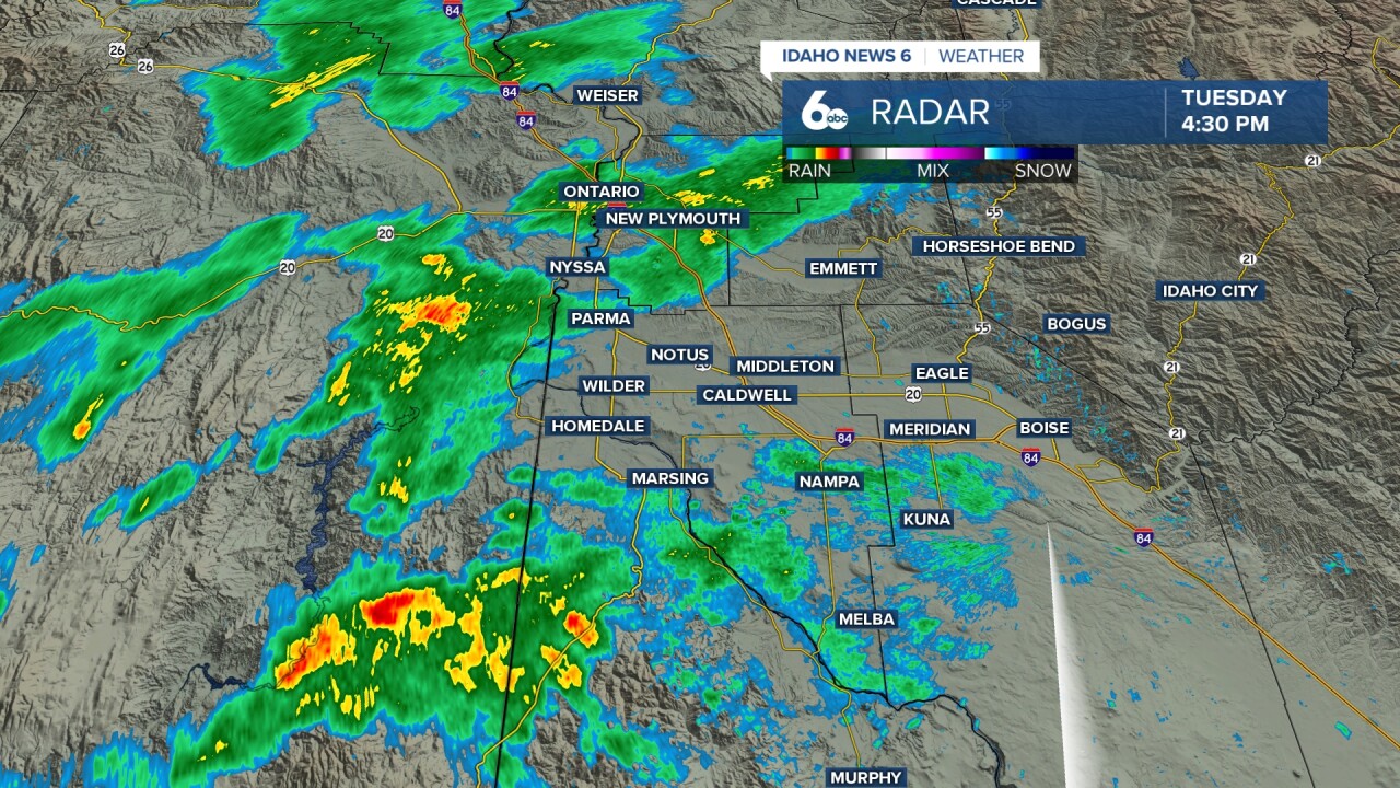


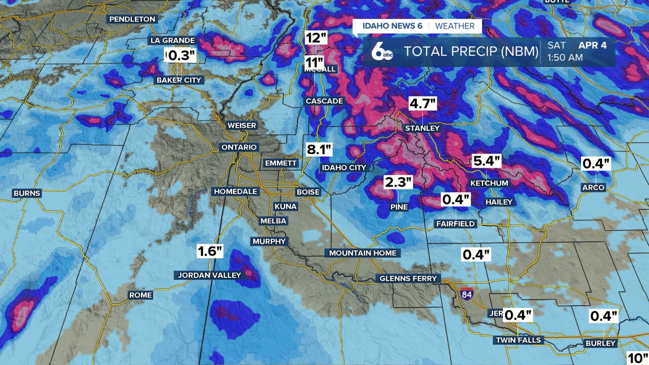
Ahead of the front, light rain and snow will continue Tuesday night with snow levels remaining above 6,000 feet. Isolated thunderstorms are possible through sunset Tuesday, with a 20 to 30 percent chance of thunder north and west of Mountain Home. These storms could produce small hail, graupel, and wind gusts up to 30 mph. A slight chance of thunderstorms will return Wednesday afternoon as the front passes, and again on Thursday as a deep upper-level low moves directly overhead.
Heavy Showers & possible Storms Wednesday, details here in my video forecast
The cold front will rapidly lower snow levels Wednesday night into Thursday morning. Snow levels will drop to 3,000 to 3,500 feet by Thursday morning, reaching valley floors in eastern Oregon and nearly reaching valley floors in Idaho. Idaho areas north of the Snake Basin will see three to six inches of snow accumulation, with localized amounts up to nine inches.

Breezy to windy conditions will develop Thursday afternoon. A Wind Advisory has been posted for the Camas Prairie and western Magic Valley, where westerly wind gusts will increase to 45 mph. Showers will decrease Thursday evening, leading to a very cold Friday morning with low temperatures dropping into the teens and 20s for most areas, while lower southern Idaho valleys stay just above 30 degrees.
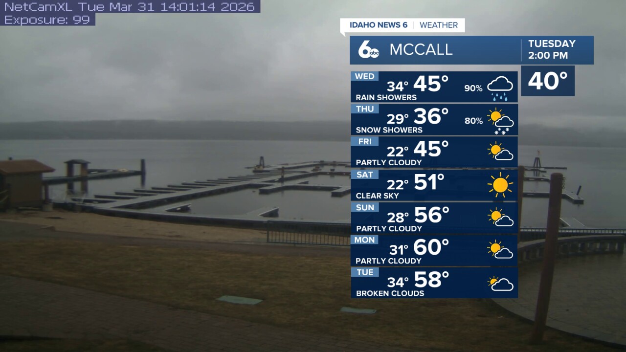
Following the cold front, a building high-pressure ridge will bring a significant warming and drying trend. Temperatures will warm five to 10 degrees each day through Monday, eventually reaching 10 degrees above normal early next week. Valley highs will climb into the low 70s, with mid-60s in the highlands and upper 50s in mountain valleys and ridges. Another low-pressure system approaching the coast hints at a return to a cool and wet pattern after a warm Tuesday.
Tonight
Showers likely and possibly a thunderstorm. Mostly cloudy, with a low around 46. Light wind. Chance of precipitation is 70%. New precipitation amounts between a tenth and quarter of an inch, except higher amounts possible in thunderstorms.
Wednesday
Showers likely, with thunderstorms also possible after noon. Mostly cloudy, with a high near 59. Wind SE 5-10 mph. Chance of precipitation is 60%.
Wednesday Night
Showers before 9pm, then showers and possibly a thunderstorm between 9pm and midnight, then showers after midnight. Low around 39. Wind W 6-10 mph. Chance of precipitation is 100%. New precipitation amounts between a quarter and half of an inch possible.
Thursday
A chance of rain and snow showers before 9am, then a chance of rain showers. Cloudy, with a high near 50. West wind 10 to 18 mph, with gusts as high as 25 mph. Chance of precipitation is 50%. Little or no snow accumulation expected.
Thursday Night
Partly cloudy, with a low around 33.
Friday
Sunny, with a high near 58.
Friday Night
Mostly clear, with a low around 35.
Saturday
Sunny & milder, with a high near 65.
Saturday Night
Mostly clear, with a low around 40.
Sunday
Sunny & very pleasant, with a high near 72.
Sunday Night
Partly cloudy, with a low around 43.
Monday
Mostly sunny, with a high near 74.
Monday Night
Partly cloudy, with a low around 47.
Tuesday
Partly sunny, with a high near 74.