


UPDATE (1:30 p.m. - 8/24/25):
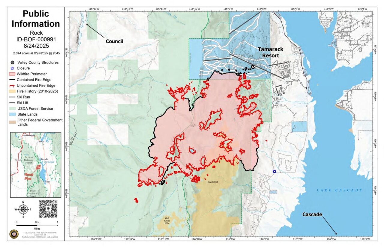
Fire crews continue to increase containment along the perimeter of the Rock Fire, which has grown to 2,844 acres, up just 20 acres from the previous day's report.
The most recent update from the Boise National Forest details how crews have laid over 100 miles of water hose line to support suppression efforts.
"Drones have been effective in detecting hot spots, helping ground crews determine where to focus their suppression efforts." - Boise National Forest
Mild weather is expected today and through next week, which should offer a bit of a break after an extended stretch of hot, dry conditions.
WM07 remains under a 'SET' evacuation order, and WM05 and WM06 remain under 'READY' orders.
See updated orders: Find My Evacuation Zone - Valley County
BOISE NATIONAL FOREST UPDATE: 8/23/25
2,844 acres, 24% containment, 887 personnel
Highlights
Firefighters have continued making progress along the fire’s perimeter, increasing containment to 24 percent. Over the last week, approximately 45 miles of hose lays have been installed along the fire’s perimeter, supported by over 70 miles of lateral hose lines. The main trunk line serves as the primary water supply line, typically positioned along the fire’s edge or along key access routes. From the trunk line, firefighters extend lateral hose lines (smaller, branching hoses) that allow them to reach deeper into the fire area. These laterals are essential for expanding coverage, enabling crews to conduct effective direct suppression and mop-up operations across challenging terrain. Sixty-four pumps have been utilized to power hose lays, maintain water pressure, and support suppression and mop-up efforts across challenging terrain.
Crews will continue mop-up operations and work to strengthen existing fireline. As objectives are met, resources will be strategically shifted to the northeast where efforts will focus on a direct suppression strategy. On the east side, crews continue working to strengthen control lines and are moving closer to establishing initial containment. Mop-up is the process of extinguishing remaining heat sources within a wildfire’s perimeter, near containment lines. Firefighters cool hot spots, dig out smoldering debris, and secure the edge of the fire to prevent reignition or escape. This critical step ensures the fire stays within the established containment lines.
Drones have been effective in detecting hot spots, helping ground crews determine where to focus their suppression efforts. As crews continue working to secure the fire’s perimeter, residents may still see smoke in the area. This is due to interior pockets of vegetation that continue to smolder and burn. These interior hotspots are expected, and while they may remain visible, firefighters are securing the edges of the fire to ensure it does not spread.
Fire Weather
Conditions will be slightly cooler Sunday and less dry as high pressure weakens, with highs ranging from the mid-70s to around 90°F and minimum humidity of 16–22%. Light terrain-driven winds are expected, with west winds of 4–8 mph and gusts up to 16 mph on mid to upper slopes. Smoke should lessen compared to Saturday, with high clouds moving in throughout the day. Overnight humidity recovery will improve slightly, though east-northeast gusts of 10–15 mph may redevelop on upper slopes.
UPDATE (1:30 p.m. - 8/23/25):
The Rock Fire was measured on Saturday morning at 2,824 acres. The fire is now 6% contained, and according to the most recent update from the Boise National Forest, "firefighters continue to implement direct attack strategies, making progress along key sections of the fire’s edge."
However, fire crews admit that containment efforts remain challenging due to the fire's lack of a "clearly defined edge."
There has been steady progress on the east side of the fire, where crews continue to reinforce containment lines.
"Helicopters have delivered approximately 1,145 water bucket drops to cool spot fires and support ground crews, while fixed-wing aircraft have completed 477 retardant drops to slow the fire’s spread and reinforce control lines. Sustained air operations continue to be a critical part of the overall firefighting strategy." - Boise National Forest
BOISE NATIONAL FOREST UPDATE: 8/23/25
2,824 acres, 6% containment, 884 personnel
Highlights
Due to the diligent work of firefighters over the past 10 days, there is an increase to 6% containment. Suppression and containment efforts remain challenging due to a combination of factors, including dry, receptive fuel types, weather conditions, extensive bug-kill, and an abundance of dead and downed vegetation. Steep, rugged terrain further complicates operations. Despite these difficult conditions, firefighters continue to implement direct attack strategies, making progress along key sections of the fire’s edge.
Although the Rock Fire has reached 6% containment, the absence of a clearly defined edge has made containment challenging. A full suppression strategy has effectively limited significant growth and helped keep the fire within established control lines. Firefighting efforts are making steady progress, particularly on the east side of the fire, where crews are working to strengthen lines and move closer to establishing initial containment.
As objectives are being met in the northwest corner of the fire, aircraft are now shifting focus to the east side of the fire to support ground efforts on strengthening the perimeter. Since the start of the incident, aerial resources have played an essential role in firefighting efforts. Helicopters have delivered approximately 1,145 water bucket drops to cool spot fires and support ground crews, while fixed-wing aircraft have completed 477 retardant drops to slow the fire’s spread and reinforce control lines. Sustained air operations continue to be a critical part of the overall firefighting strategy.
Two Unmanned Aerial System (UAS or drone) equipped with infrared technology are being utilized to detect heat signatures and identify potential hot spots across the fire area. The drones will conduct a comprehensive assessment of the entire perimeter to provide data to ground crews. This information will enhance situational awareness and support strategic decision making in ongoing suppression efforts.
Fire Weather
Saturday, light terrain driven winds are expected, except on mid to upper slopes where afternoon winds will be west-northwest at 4-8 mph with gusts to up to 15 mph. Smoke will continue to move into the area from the Island Creek fire, reducing visibility in the morning with some improvement by the afternoon. High clouds will increase late in the afternoon. A strengthening thermal belt will result in east-northeast gusts of 10-15 mph on upper slopes as we move into the afternoon.
UPDATE (11:50 a.m. - 8/22/25):
The Rock Fire remains active and grew overnight to 2,813 acres. The fire is still 0% contained.
According to a release from the Boise National Forest, crews are still working to establish and fortify containment lines around the fire's perimeter.

BOISE NATIONAL FOREST UPDATE: 8/22/25
2,813 acres, 0% containment, 884 personnel
Highlights
Crews continue to make progress securing the fire’s edge. Of the 33-mile perimeter, 29 miles is constructed dozer line, 2.6 miles is handline, and 1.2 miles is combination of dozer and handline. These efforts strengthen containment features and provide firefighters greater ability to hold the fire within established boundaries. Containment will be declared once fire managers are confident the fire will not cross these lines. Firefighters have installed hoselays and are mopping up along the perimeter, working 50–300 feet in from the fire’s edge depending on vegetation and terrain, and once this work is completed, containment is expected to increase. Firefighters are working in extremely steep and rugged terrain, with some areas rising as much as 1,600 vertical feet, which makes both access and firefighting operations especially challenging.
Aircraft supported ground crews by cooling spot fires on the northwest corner, where winds carried embers beyond the main fire. Aircraft require a ground contact and firefighters on the ground to be effective. As objectives are met in this area, crews will be around the fire to strengthen other parts of the perimeter.
To the northwest, heavy equipment is building a contingency line along Forest Road 218 toward Jungle Creek and down the ridge bordering Tamarack Resort. This line will connect with existing containment features on the south side of the resort, creating an additional layer of protection should the fire move past previously built dozer lines. These efforts are focused on keeping the fire from advancing toward nearby communities and recreation areas.
South of Tamarack Resort and along the eastern edge, crews continue to mop up and remove hazard trees while improving old roads to ensure safe, quick access to spot fires. In the rugged southern terrain, firefighters are spiked out on the line for multiple days, allowing rapid response to spot fires outside the perimeter. Aircraft have also flown in portable water tanks to aid in cooling hotspots and support suppression in hard-to-reach areas, ensuring the fire remains within established containment lines.
Fire Weather
Winds will be out of the west-northwest at 4 mph, with gusts up to 17 mph. Temperatures are expected to reach the mid-80s, and the hot, drying trend will continue into the weekend. This drying trend will lead to an increase in fire activity with the potential of smoke impacting nearby communities. Smoke is also likely to settle overnight as temperatures cool, but is expected to lift during the day as temperatures rise.
UPDATE (7:00 p.m. - 8/21/25):
WATCH: Rock Fire Community Meeting at the Donnelly Rural Fire Protection District
UPDATE (11:00 a.m. - 8/21/25):
"SET" evacuations are still in place for the WM07 zone in Valley County as crews continue to work on containing the Rock Fire. The WM06 and WM05 zones are under "READY" orders.
There are 853 personnel assigned to the fire, which was last measured at 2,797 acres and is 0% contained.

A recent update from the Boise National Forest says that containment and mop-up operations are underway at various points around the fire's perimeter.
A containment line protecting Tamarack Resort from further spread appears to be holding.
Hot and dry conditions are forecasted for the rest of the week.
"Firefighters remain actively engaged in containment and mop-up operations across multiple areas of the fire, making steady progress despite challenging terrain and thick vegetation." - Boise National Forest
A community meeting regarding the Rock Fire is scheduled for tonight at 6 p.m. at the Donnelly Rural Fire Protection District (244 W Roseberry Rd, Donnelly, ID 83615).
UPDATE (Noon - 8/20/25):
The Rock Fire remains active and continues to grow slowly. The fire was recently measured at 2,743 acres and is 0% contained.
Residents in the WM07 zone are now under a "SET" evacuation order, meaning there is a significant danger in the area and those affected should be prepared to leave at a moment's notice. The WM05 and WM06 zones remain under "READY" evacuation orders.
Crews on the ground continue to bolster containment lines to limit the fire's spread.
A community meeting is scheduled for 6 p.m. on Thursday at the Donnelly Rural Fire Protection District to discuss relevant fire updates. A video recording of the meeting will be available on the Boise National Forest Facebook page following the meeting.

UPDATE (11 a.m. - 8/19/25): The Valley County Sheriff’s Office has upgraded the evacuation status for Zone M-07 from “Ready” to “Set.” Residents in this area should be prepared to leave immediately if conditions worsen.
“As the fire has moved closer to values at risk, we want to ensure that residents are prepared to leave if conditions warrant,” Sheriff Kevin Copperi said in a press release.
A Code Red alert will be sent to residents in the affected zone. Officials are urging people to review evacuation procedures, prepare essential items, and stay tuned to local alerts.
Idaho News 6 will continue to update this story as more information becomes available.
UPDATE (9 a.m. - 8/18/25):
According to USFS, the Rock Fire saw minimal growth overnight thanks to the diligent work of firefighters and lingering moisture in the air. The flames now spread across 2,673 acres with no containment.
Aircraft had a later start than usual on Sunday, but after the fog cleared, helicopters and scooper planes were able to provide steady support. Aircrafts have now dropped a combined 348,714 gallons of water and 577,603 gallons of retardant.
Crews on the ground are working this morning to continue reinforcing containment lines and they say containment will be achieved once they're confident that the fire will not cross over containment lines. Yesterday, crews were able to establish portable water tanks allowing the use of hoses.
A 5% chance of showers and thunderstorms today combined with light to moderate winds are expected to increase fire activity.
The three Valley County evacuation zones set at "Ready" status remain in place.
UPDATE (9:00 a.m. - 8/17/25):
The Rock Fire remains active today as firefighting crews continue to engage the blaze in a variety of ways. The fire was most recently measured at 2,335 acres and is 0% contained.
The fire is actively burning within the southern boundary of Tamarack Resort.
Suppression efforts include deploying aerial support to deliver water and retardant to hot spots while firefighters on the ground build and reinforce containment lines using dozers and hand crews to limit the fire's spread.
"The subalpine fir in the fire area is very conducive to spotting, which occurs when embers are carried by the wind and ignite new fires outside of the main fireline." - USFS
According to an update from the US Forest Service (USFS), the Rock Fire is also producing "rollout," which is when burning logs or debris roll downhill, igniting trees and other vegetation.
Overnight, a 50-acre spot fire was reported near the west side of the fire's perimeter that was caused by downslope winds. Crews are working hard to limit the fire's spread in that area.
"On the south end of the fire, firefighters are working in and around a large aspen stand, which will help slow fire spread because aspen trees hold more moisture and are less flammable than conifer trees. Fire managers continue scouting for natural fuel breaks, such as rocky outcroppings, that can serve as barriers to help contain the fire." - USFS
There is a chance of thunderstorms this afternoon, accompanied by winds from the west and southwest. Gusts could reach up to 20 mph.
'READY' evacuation orders remain in effect for three zones in Valley County.
See up-to-date evacuation orders here: Find My Evacuation Zone - Valley County

WATCH: Breaking down the 3 different levels of evacuation orders —
UPDATE (9:16 a.m. - 8/16/25):
After being briefed on the Rock Fire yesterday, the Great Basin Complex Incident Management Team has assumed command over firefighting efforts. The fire is now at 2,329 acres.
Fire crews continue to combat the fire directly, using bulldozers to build containment lines while aerial teams, including Super Scoopers, Single-Engine Airtankers, and helicopters, continue to drop water and retardant on the blaze.
A Temporary Flight Restriction remains in place. Flying aircraft in the vicinity of the fire, including drones, is prohibited.
There is a 30% chance of scattered thunderstorms tonight near Donnelly, and a Flash Flood Watch will go into effect at noon and last until 11 a.m. tomorrow. Flash flooding over burn scars can result in landslides and debris-filled runoff events.
Three Valley County evacuation zones remain in "READY" status.
Find up-to-date evacuation order information here: Find My Evacuation Zone - Valley County
"On the north end near Tamarack Resort, crews are aggressively seeking out and extinguishing hot spots while reinforcing control lines along Forest Road 346 and the Tamarack Ski Run “Bliss Run.” On the west side, the fire has reached ponderosa pine stands, where crews are successfully working directly on the fire’s edge. On the south side, at the heel of the fire, dozers and engines are working to strengthen containment lines while bringing water into the area to extinguish remaining heat. Along the southwest flank, crews are connecting dozer lines to increase containment. On the east side, firefighters are constructing indirect line building containment away from the active edge using dozer lines and Forest Road 346 to get ahead of the fire in steep, difficult terrain dominated by subalpine fir and mixed conifer." - US Forest Service Update
SEE HERE: Tamarack residents holding tight as fire continues to burn along the resort's boundary
UPDATE (9:10 p.m. - 8/15/25):
According to a Forest Service News Release, fire crews are continuing to maintain the containment line of the Rock Fire, which currently measures at 2,800 acres.
Handcrews and engines are focused on areas with residents close by, such as West Mountain Road and Tamarack Resort.
Helicopters and small air tankers have been employed to contain the fire's edge. The only closed campground along Lake Cascade is Upper French Creek Campground.
The Forest Service reports that "Great Basin Team 6, a Complex Incident Management Team was in-briefed earlier today and will be taking command of the fire tomorrow, Aug. 16, at 6 a.m."
UPDATE (9:30 a.m. - 8/15/25)
Firefighters are continuing to battle the Rock Fire, which is reported to have burned approximately 2,356 acres. The wildfire has 0% containment.
Firefighters are building direct and indirect containment lines to prevent the fire from affecting nearby infrastructure.
As of Thursday evening, the fire is burning near Tamarack Resort, and flames have been spotted on the Bliss ski trail.
"The fire has spotted up against the Tamarack Resort’s Bliss ski run, with crews aggressively working to keep it in check there." - USFS
A total of 252 firefighters and support staff are currently deployed to the fire. According to a release from the US Forest Service, that number includes "three Hotshot crews, three 20-person Initial Attack handcrews, two 10-person handcrews, 11 engines, and 2 dozers. Aircraft include 4 Large Air Tankers, 1 Very Large Air Airtanker, 6 Water Scoopers, and 8 helicopters."
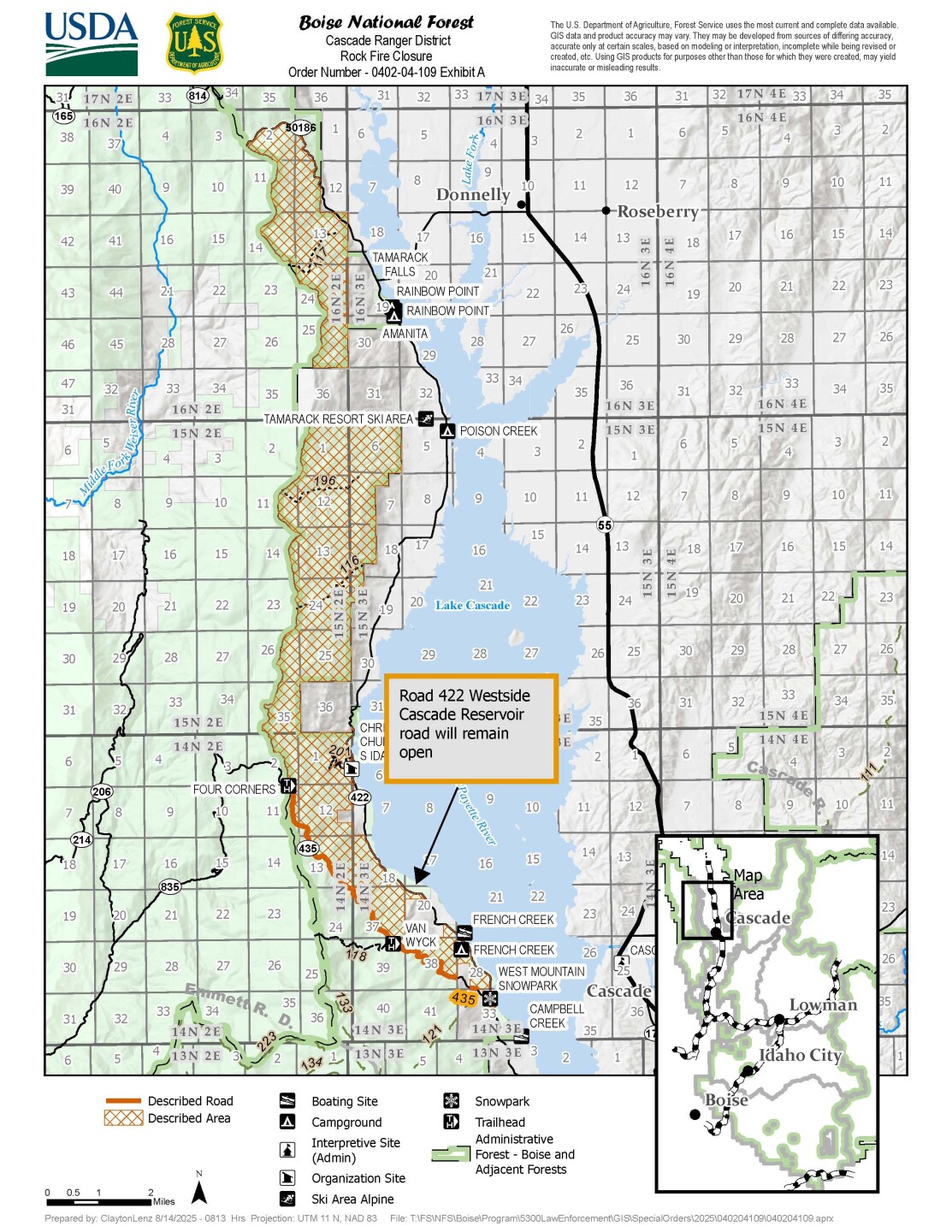
On Thursday afternoon, the U.S Forest Service issued an order to close down several areas, roads, and trails near the Rock Fire, which will remain in effect until the end of the year, or until the order is rescinded.
WATCH: Neighborhood Reporter Brady Caskey watches firefighters attack the flames
The closure, which makes up a large section on the west side of Lake Cascade, starts where Forest Road 435 meets the forest boundary, then follows Road 435 southeast, wraps around along the boundary, connects briefly with Forest Road 422, and continues back to the starting point.
The closure forms a loop that includes all the forest land inside these lines, but excludes Forest Road 422 itself. The full closure details can be found here.
The lightning-caused fire was one of several that started late on Aug. 12. An overnight heat detection flight mapped the fire’s size, and crews worked through the night on Wednesday, building containment lines and creating space around homes and infrastructure.
Several long-range spot fires were found within Tamarack’s ski runs but were quickly suppressed, officials said.
The Valley County Sheriff’s Office has issued a “ready” evacuation notice for zones WM 05, WM 06, and WM 07 — from West Roseberry Road south to Bear Trail along West Mountain Road.

Firefighting resources on the scene include three Hotshot crews, two 20-person Initial Attack handcrews, two 10-person handcrews, 11 engines, and two bulldozers. Several aircraft are also expected to assist with fire efforts on Thursday, including four large air tankers, one very large air tanker with an 8,000-gallon capacity, six single-engine air tankers, four water scoopers, and five helicopters.
On Wednesday, Tamarack Resort suspended all operations until further notice due to fire activity.
WATCH: Senior Reporter Don Nelson provides an update on the fires from Tamarack
A Complex Incident Management Team is expected to arrive on Friday to provide additional staffing and resources.
Residents can review wildfire evacuation procedures, sign up for emergency alerts, and find their evacuation zones online. Idaho News 6 will continue to provide updates as more information becomes available.