


UPDATE (8:00 p.m. - 8/31/25):
Containment has increased to about 75%, as firefighters enter the third week of suppression efforts against the Rock Fire.
The containment level tripled since last week, jumping from 24% to 74%.
Until August 23, fire crews were at zero percent containment.
In Facebook posts from the U.S. Forest Service, it is reported that the fire is not spreading as rapidly, even with warm and dry conditions returning to the area.
WM07 is still set in 'READY' evacuation status. For the latest updates on evacuation information, visit the Valley County Evacuation Zone map.
UPDATE (2:30 p.m. - 8/30/25):
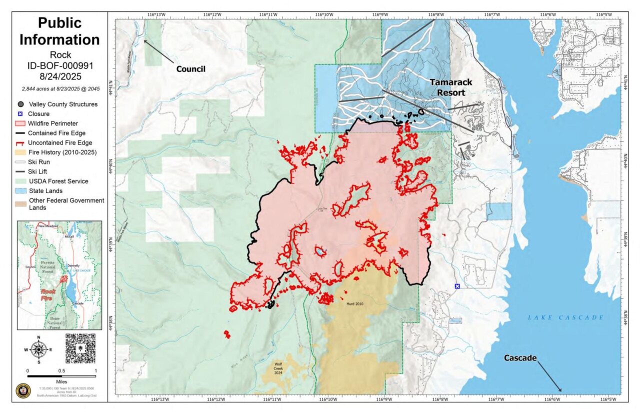
Containment of the Rock Fire has risen to 65% after burning nearly 2,800 acres.
According to a press release on behalf of the Idaho Department of Lands, the Great Basin Complex Incident Management Team 6 is transferring command of this fire to the Nevada Type 3 Team 3 on Sunday, August 31.
Valley County Sheriff's Office cleared WM06 from any evacuation notice, but WM07 will remain at 'READY' at this time.
A 'READY' evacuation status means that a threat or hazard is within the area, and emergency services may notify those in the area if conditions worsen.
The fire, which was caused by lightning, started on August 12 and is entering its third week of suppression efforts.
UPDATE (2:00 p.m. - 8/27/25):
The Valley County Sheriff's Department has downgraded evacuation orders for areas near the Rock Fire.
WM05's is no longer under an evacuation order. WM06 is still under a 'READY' order, and WM07 was downgraded from 'SET' to 'READY.'
See updated orders: Find My Evacuation Zone - Valley County
UPDATE (11:30 a.m. - 8/27/25):
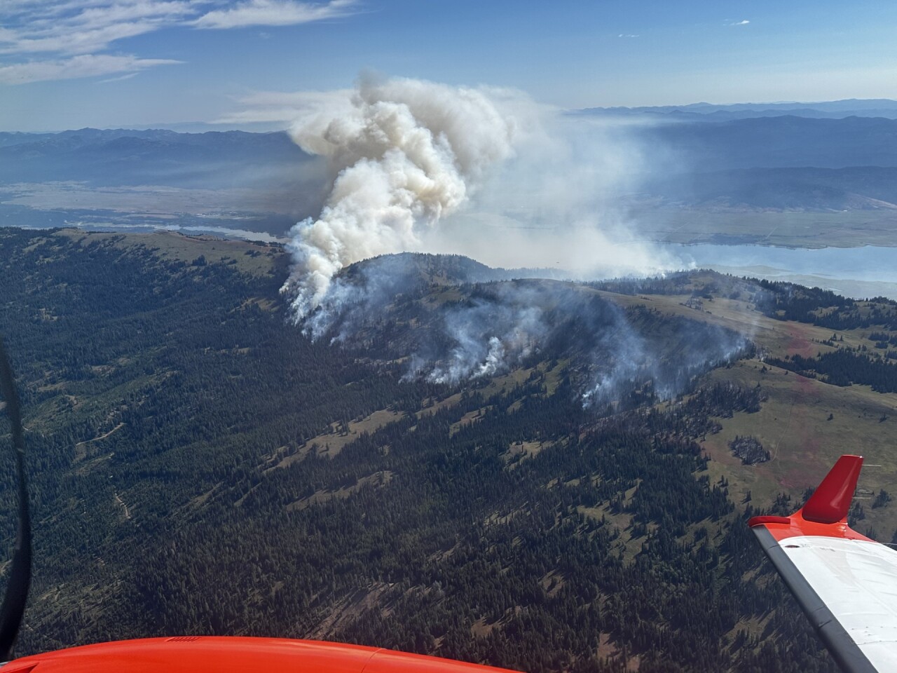
Strong, soaking rains are helping fire crews as they continue to work towards full containment of the Rock Fire, which is burning near Tamarack Resort.
The fire did not grow overnight.
"Additional outward growth of the fire’s footprint is not expected, especially as heavy rains are received over the fire." - Boise National Forest
A release from the Boise National Forest indicates a downsizing in personnel over the coming days due to progress made along the fire's edge.
WM07 remains under a 'SET' evacuation order, and WM05 and WM06 remain under 'READY' orders.
See updated orders: Find My Evacuation Zone - Valley County

BOISE NATIONAL FOREST UPDATE: 8/27/25
2,792 acres, 42% containment, 773 personnel
Highlights
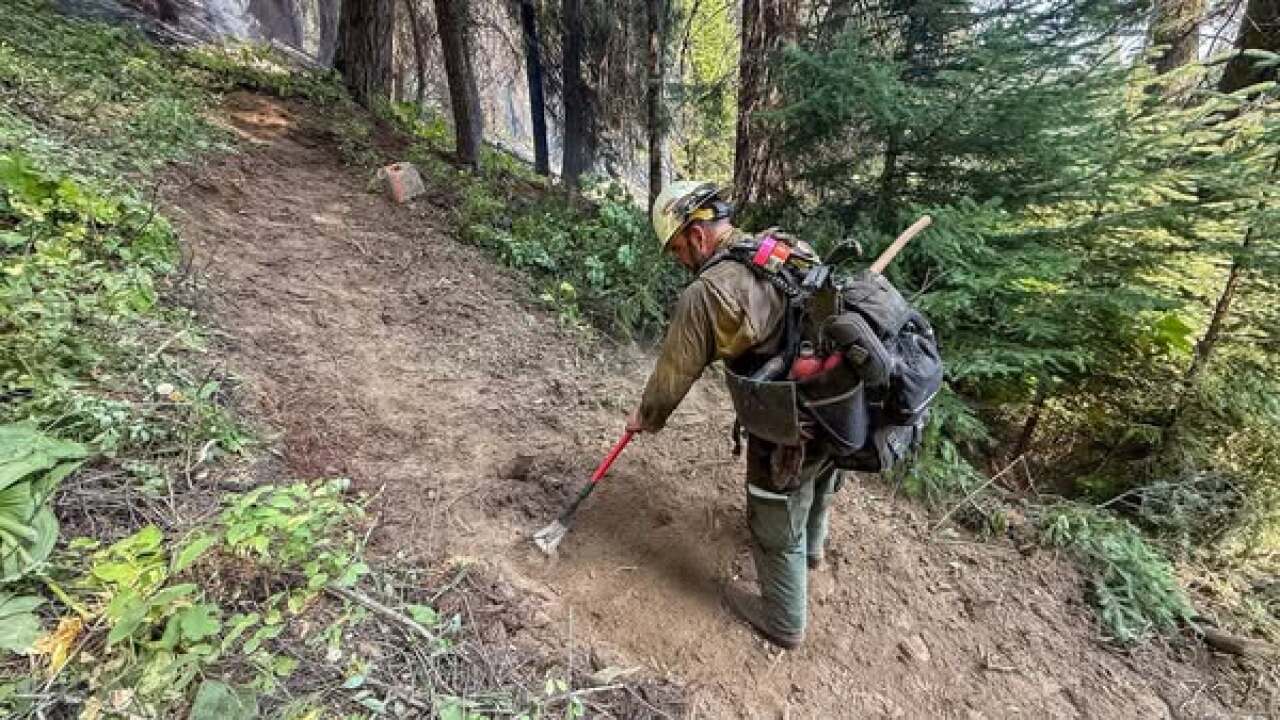
As containment increases and firefighting objectives are met, crews and equipment will gradually begin to downsize over the coming days. Efficiencies are being made in the hose lays so that water pumps and hoses that are not needed can be removed, while firefighters can continue to use water effectively on the areas with the most heat on the fire’s edge. Water bars have been constructed in areas that could receive and channel heavy water flow, like constructed bulldozer lines in the Tamarack Resort area. Aerial resources remain available to support ground operations as needed as long as weather conditions allow for safe operations.
Safety of firefighters and the public is always the top priority, and rains in a recently burned area present unique challenges, especially in lower elevations of the mountain. Outflow winds from storms can bring down snags dead or weakened trees that create dangerous overhead hazards. Burned soil can also become extremely hydrophobic, meaning it repels water rather than absorbing it, increasing the potential for flooding and mudslides. In addition, dirt access roads that become waterlogged create unsafe driving conditions for personnel traveling to remote parts of the fire.
Additional outward growth of the fire’s footprint is not expected, especially as heavy rains are received over the fire. There are still acres of unburned vegetation scattered within the interior, which may continue to ignite, creep, and smolder after this storm system passes, producing smoke and occasional visible flames.
Excavators are continuing to be utilized for rehabilitation work along contingency lines and dozer lines that are ready for that stage. This work involves repairing soil disturbance, re-contouring terrain, improving drainage, and reducing erosion potential. These efforts help stabilize the landscape, prevent environmental degradation, and promote natural recovery following fire containment.
Fire Weather
A flash flood watch is in effect today. Rain is expected throughout the day, and heavy rain will be possible in conjunction with thunderstorms. Strong outflow winds from passing storms are likely and could increase risk of overhead hazards like snags.
UPDATE (10:30 a.m. - 8/26/25):
As of Tuesday morning, crews continue to make progress along the fire's perimeter, with containment now at 37% and the fire size maintained at 2,792 acres.
Additional growth of the fire is not expected; however, there are around 160 acres of unburned vegetation scattered within the interior, which could ignite, creep, and smolder for days and even weeks, producing smoke and occasional visible flames.
Interior fire activity is expected until significant rainfall or sustained moisture is received to fully extinguish what remains.
Containment has been established on the northern and southeastern perimeter of the fire, and crews are continuing to work toward the middle of the eastern flank.
There is a flash flood watch that goes into effect today, August 26, at noon and continues into Wednesday evening.

Firefighters have made significant progress against the Rock Fire burning near Tamarack Resort, with containment increasing to 29% as of Monday, according to the Boise National Forest. The wildfire is now mapped at 2,792 acres, a decrease from earlier acreage reports due to more accurate mapping.
Officials said extensive hose lines are allowing crews to use water more effectively on the ground, reducing the need for air operations and limiting exposure risks for pilots and crews. Aerial resources remain available to support ground operations if needed.

Officials say that recent firefighting efforts are focused on the fire’s eastern side. Crews have established initial containment on the southeastern perimeter and are now moving northward.
Heavy equipment task forces are also working in the northern section, constructing fire breaks to slow potential fire spread. Excavators are being used to repair disturbed terrain along completed dozer and contingency lines, reducing erosion risks and helping stabilize the landscape for recovery once the fire is contained.
Despite recent progress, fire officials warn that erratic and high winds in the forecast could intensify the fire's behavior. Interior pockets of vegetation will likely continue to smolder and produce visible smoke, but crews are working to secure the perimeter.
The Rock Fire, first sparked by lightning on Aug. 12, has nearly 880 personnel still assigned to the incident.
Evacuation notices remain in place in Valley County. Zone WM07 is still under a “SET” order, meaning residents should be ready to leave immediately if conditions worsen. Zones WM05 and WM06 remain under “READY” status.
See updated orders: Find My Evacuation Zone - Valley County
The Boise and Payette National Forests have also issued area, road, and trail closures near the fire.
Monday’s forecast calls for cooler conditions with highs in the upper 60s to low 80s. There is a 30% chance of thunderstorms by the afternoon and evening, which could bring gusts up to 30 mph along with light rain. Officials cautioned that storms may be a mix of wet and dry, bringing both some relief and potential new fire risks.
WATCH: Breaking down the 3 different levels of evacuation orders —