

Happy December, it's a new month and the start of Meteorological Winter!
A new upper-level trough will slide south out of British Columbia tonight and move into our area on Tuesday. This system will reflect the weekend and bring light snow again. Most valley locations should see only a dusting to around a half-inch, while the higher terrain — especially northern peaks and far southeast Owyhee County near the Nevada line — could pick up 1–3 inches.

Road impacts below about 4,500 feet should stay minimal with mainly wet pavement. The system exits by Wednesday morning with improving skies and a shift to breezy northwest winds during the afternoon.
Now, the offshore ridge weakens late week, allowing the jet stream to sag south and open the door to a wetter pattern starting (skiers and snowboarders rejoice) Thursday night and Friday. A strong west–northwest flow develops overhead, sending periodic waves of Pacific moisture through early next week.

These systems will be milder, so expect mainly rain in the valleys and a mix of rain and snow in the mountains. The first disturbance arrives Friday into early Saturday, bumping up precipitation chances — around 40–60% for the lower elevations and 60–90% in the mountains. Snow levels rise to roughly 5,500–7,000 feet Friday night, then lower again as cooler air works in behind the warm front.
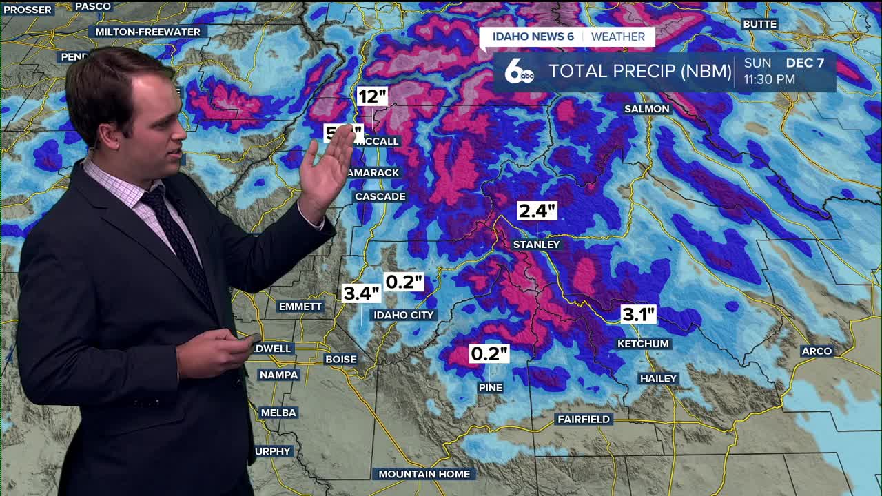
From Saturday night through Monday, snow levels average 3,500–5,000 feet, with ups and downs as each wave moves through. Valley precipitation chances run about 10–30%, while the mountains stay more active at 30–60%. Higher peaks could see moderate to even heavy snowfall totals by early next week.
Temperatures run 5–10 degrees above normal, and the active pattern brings occasional breezy conditions.
EXTENDED FORECAST:
TUESDAY
A slight chance of rain and snow showers before 11am. Mostly cloudy, with a high near 43.
WEDNESDAY
Early morning fog followed by sunny conditions and a high near 41.
THURSDAY
Partly sunny with a high near 43. 30 percent chance of rain in the evening.
FRIDAY
A 50 percent chance of rain, mostly cloudy, with a high near 48.
SATURDAY
Rain likely before 11 am, mostly cloudy with a high near 49.
SUNDAY
A 30 percent chance of rain. Partly sunny, with a high near 49.
MONDAY
A small chance of rain, partly sunny with a high near 50.
Stay up to date right here https://www.instagram.com/sophiacruzwx/?hl=en