

We’re kicking off a brand-new week with temperatures running about 10-15 degrees above average, and this warmth is sticking around for several days.

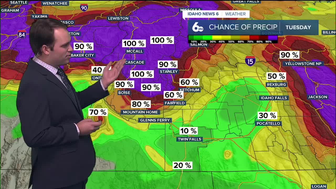
A strong, moisture-rich atmospheric river is impacting the Pacific Northwest and funneling warm air straight into Idaho. Because of that, snow levels are rising rapidly, meaning most of the precipitation this week will fall as rain — even across the mountains. Snow will mainly be limited to the highest elevations above 7,000 to 8,000 feet, and even there, any snow that does fall will be heavy and wet. A warm front moves through this evening, helping showers become more widespread from northwest to southeast. Rain first develops in the central mountains late this morning, then reaches the Treasure Valley by this evening, near 6 PM.
RELATED | Bogus Basin and Sun Valley ski resorts begin to open trails
Once the rain starts, the mountains will stay unsettled through at least Wednesday night, with periods of light to moderate — and at times heavier — rain. Total moisture amounts in the higher terrain could reach one to two inches, with isolated spots possibly picking up even more. At lower elevations, rainfall stays lighter — generally a quarter inch or less — and some areas south of the Snake River may see very little rain at all. Strong winds higher up will also be an issue, with gusts up to 30–45 mph along exposed ridges, which could make travel tricky in the mountains.


All of this rain combined with snowmelt will cause rivers and streams to rise through mid-week. Flooding is not expected at this time, but waterways will be higher and faster, and will be something to keep a close eye on.
Through the rest of the week, unsettled mountain showers continue into at least Thursday, though it won’t be a constant downpour. Thursday stays breezy, especially in open areas and higher elevations, with gusts up to 20–30 mph. Temperatures remain unusually mild, with afternoon highs in the 40s and 50s each day.
By Friday and Saturday, high pressure builds in, bringing drier and calmer conditions. With all the recent moisture and lighter winds, we could see fog and low clouds developing in the valleys, especially during the overnight and morning hours. Even with that, temperatures will still run 10 to 20 degrees above normal.
Looking ahead to late Sunday into Monday, forecast models hint at another cold front and system approaching, which could bring increasing rain chances and a gradual cooldown as colder air slowly starts to work back into the picture.
Stay up to date right here @sophiacruzwx
