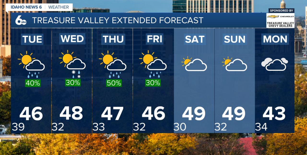
After an unusually warm and dry stretch, a much cooler and more active weather pattern is settling into southwest Idaho and eastern Oregon. Several rounds of precipitation are expected throughout the week, bringing valley rain, mountain snow, and even the possibility of a few snowflakes reaching the Treasure Valley.
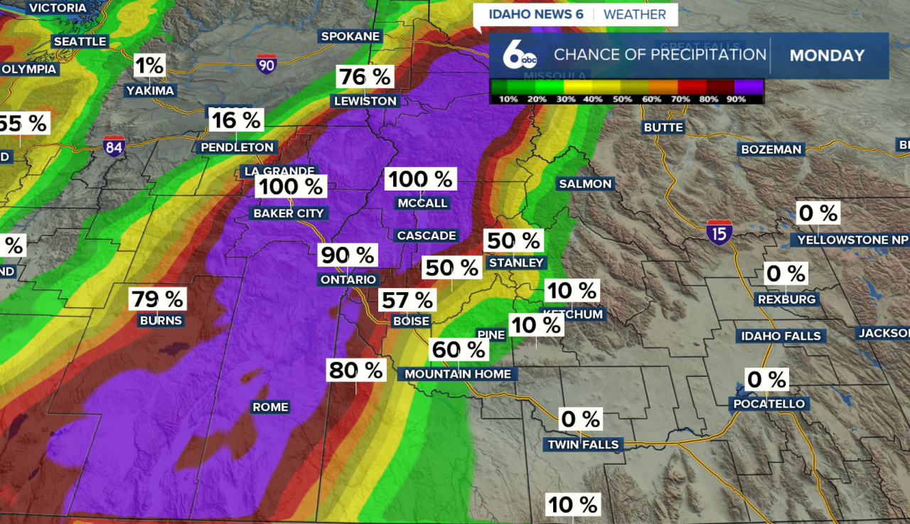
Monday into Tuesday: Widespread rain will continue across eastern Oregon, expanding into southwest Idaho by tonight. Snow levels will initially remain elevated between 6,500 and 7,500 feet, limiting snowfall to the higher mountain elevations. However, colder air moving in behind a cold front will lower snow levels to around 3,500–4,500 feet by early Tuesday. Precipitation should gradually taper off Tuesday afternoon.
Wednesday through Friday: Following a brief break, another Pacific storm system will bring additional rain and mountain snow. Snow levels could briefly drop to valley floors early Wednesday, creating the potential for a rain/snow mix or even a light dusting in parts of the lower Treasure Valley. Temperatures will remain near or slightly below normal through the end of the week.
What does this mean for ski resorts?
With ski resorts such as Bogus Basin targeting an opening this weekend, this week's storms could provide some much-needed natural snowfall.
Forecast guidance suggests 5–10 inches of snow are possible across higher mountain peaks by early Saturday. However, snowfall totals will vary significantly with elevation (above 7,000 ft). Colder temperatures will also help snowmaking operations, potentially helping resorts build early-season snowpack.
The big question: Will enough snow accumulate in time for opening weekend? While the forecast is becoming more likely for winter sports, opening decisions will depend on actual snow coverage, snowmaking conditions, and resort operations. For now though, it's looking fairly promising
Opening dates:
Bogus Basin: Nov 21st & 22nd
Brundage: Nov 27th
Sun valley resort: Nov 26th
Warnings & Advisories
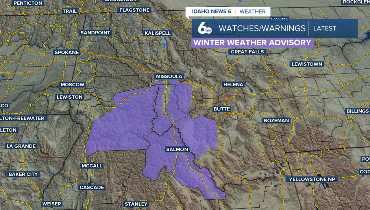
A Winter Weather Advisory has been issued for parts of east-central Idaho, including western and eastern Lemhi County, from 11 p.m. Monday through 11 p.m. Tuesday. Snow is expected above 3,500 feet, with the highest accumulations of 4 to 9 inches possible near Williams Creek Summit and Lost Trail Pass. Other mountain passes could receive 2 to 4 inches, while Gilmore could see 1 to 3 inches. Snow-covered and slick roads could make travel difficult, especially over mountain passes and along backcountry roads. Drivers should use caution and prepare for hazardous conditions during both the Tuesday morning and evening commutes.`
Looking ahead to the weekend
A brief break in precipitation is possible early Saturday before another Pacific system approaches late Saturday into Sunday. Confidence remains lower regarding the track and moisture associated with this next system, but additional mountain snowfall is possible.