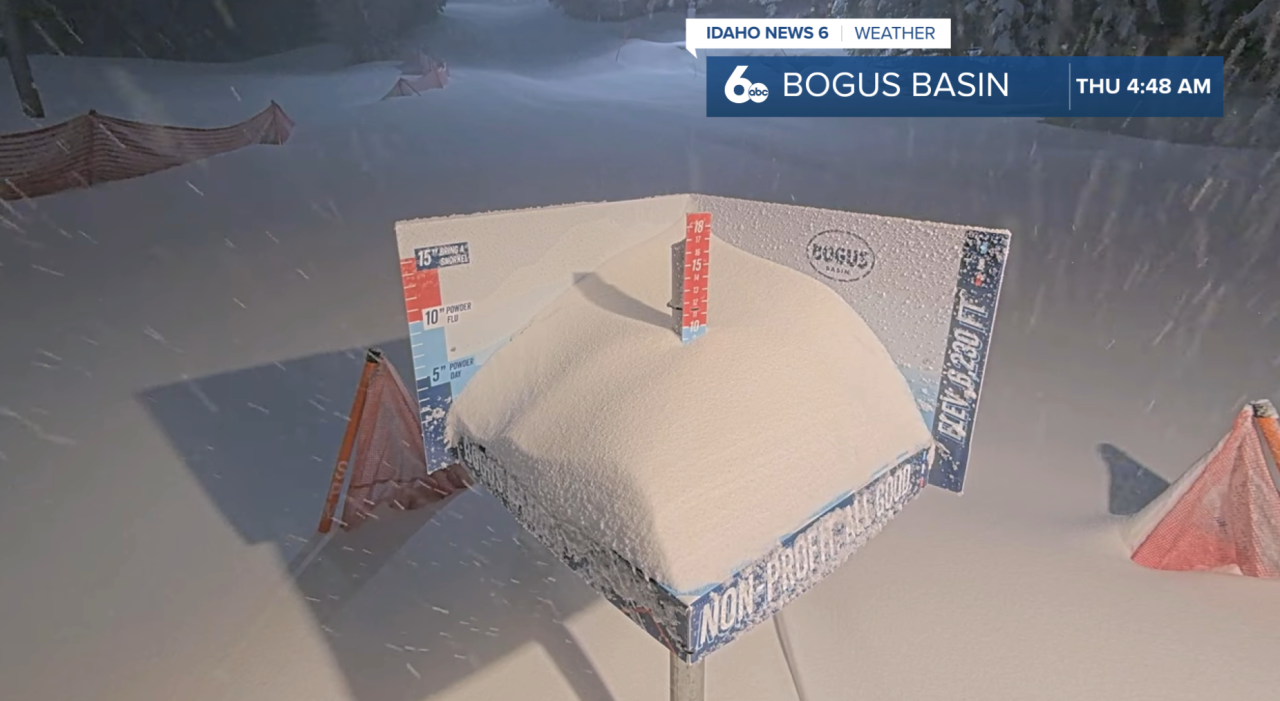
The cold front brought heavier rain throughout Wednesday and moderate-to-heavy snow. Snow totals from the latest system were a bit higher than expected in some spots. Bogus Basin ended up seeing the biggest snowfall, picking up around 10 inches from the storm. Forecast models had been suggesting closer to 3 to 6 inches, so the mountain definitely overperformed compared to earlier projections. That fresh snow should make for some great conditions if you’re planning to head up the mountain this weekend.
Heads up as you step out the door this Thursday — it’s going to be a windy one. Strong northwest winds will continue through this evening, especially across south-central Idaho and the Western Magic Valley, where gusts could reach up to 50 mph. A Wind Advisory remains in place for those areas, and drivers — especially along east-west roads — should plan for some gusty crosswinds.
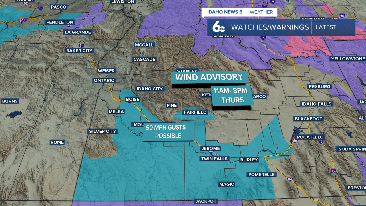
Outside of the wind, conditions will gradually dry out through the day. A few light showers lingered early this morning, but most valley locations will stay dry with skies slowly clearing. Temperatures today will run cooler than yesterday, sitting about 5 to 10 degrees lower than what we saw midweek. In the mountains, a few light snow showers are still possible through the afternoon, but any additional accumulation will be minimal.
Forecast: Mountain snow returns and a Windy Thursday
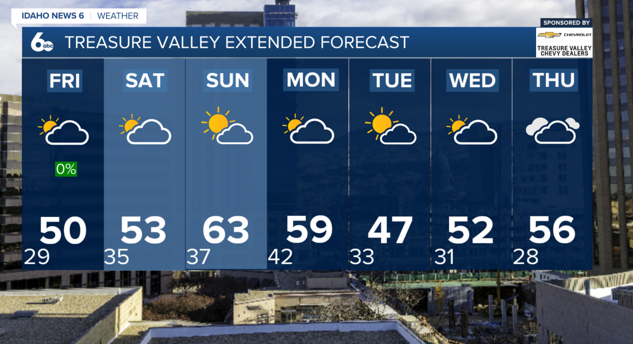
Looking ahead to Friday, the weather turns much quieter as a ridge of high pressure begins to build in from the west. That will bring dry conditions and calmer winds, though temperatures will stay near or just slightly below normal for early March.
The warming trend really begins heading into the weekend. By Saturday, temperatures climb a few degrees above normal with a mix of sun and increasing high clouds. Overall, it will be a dry start to the weekend and a nice break from the unsettled pattern we’ve seen recently.
Sunday looks to be the warmest day of the stretch, with temperatures running 5 to 10 degrees above normal under partly cloudy skies. Clouds will start to increase later in the day as the next weather system approaches.
Early next week, another dry cold front moves through Monday into Tuesday. Moisture with this system looks limited, so most valley locations will stay dry, but the central Idaho mountains could see some snow showers. The bigger impact will once again be gusty winds, especially Tuesday afternoon when some areas could see wind gusts over 30 to 40 mph.
Beyond that, a northwest flow pattern keeps things a little unsettled through midweek, with occasional mountain precipitation chances, while temperatures gradually warm again heading into Wednesday and Thursday.
So the main takeaways: windy conditions today, quieter weather Friday, a warmer and mostly dry weekend ahead, and gusty winds returning early next week.
Treasure Valley Extended Forecast