Good Morning Everyone! This morning and afternoon will feel noticeably colder. Bundle up!

A weather system moving through the region today will bring gusty winds and a noticeable drop in temperatures. A cold front is pushing east this morning, bringing breezy northwest winds across much of southwest Idaho and eastern Oregon. The strongest wind gusts will be in the Magic Valley, where gusts could reach 35 to 40 mph at times this afternoon. A wind advisory is in effect for the eastern Magic Valley this afternoon with gusts up to 55 mph possible. Put away the patio pillows and hunker down any loose items around your home.
Snow and a rain-snow mix will continue early today across the west-central Idaho mountains and parts of the Magic Valley, but this activity will fade as the system shifts east. Another weaker band of precipitation may develop later today, bringing scattered snow showers back to the mountains. As colder air moves in behind the front, snow levels will fall to valley floors, though most valley locations are expected to remain dry.
By later today and into tonight, snow showers will mainly be confined to the west-central Mountains. Valley areas stay dry through Saturday as the storm system exits the region.
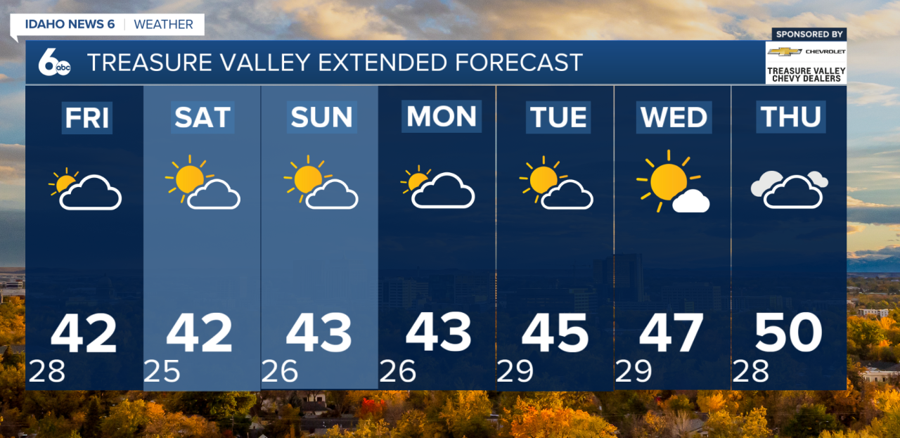
Looking ahead, high pressure builds in from the Pacific Northwest beginning Friday afternoon and lasting through the weekend. This will bring dry and quiet weather, but it also sets the stage for valley inversions. Light winds and trapped cold air will allow temperatures in the valleys to stay cooler, while mid-slopes and ridgetops run warmer than average. Morning fog and low clouds are likely at times, especially in the Snake River Valley and other sheltered valleys.

Into early next week, the ridge remains in control. Dry conditions and the development of an inversion continue through much of the week.
Overall, expect a windy and colder day today, followed by a calm, dry stretch heading into the weekend—with chilly, foggy mornings likely in the valleys.