


Hump Day has arrived! And thankfully, today won’t be nearly as rainy as yesterday.
On Tuesday, Boise picked up 0.51” of rainfall, while ski areas like Brundage and Tamarack Resort saw up to 9 inches of fresh powder. ❄️
WATCH: Forecast calls for mild weather to close out the week
We’re not done just yet, though.
A weak cold front sliding in from the northwest will shift showers SE through the day. Bringing showers to the Magic Valley and East Central Mountains for the morning commute. The Treasure Valley will still get a few spotty showers, but it won't be an all-day rain event such as Tuesday.
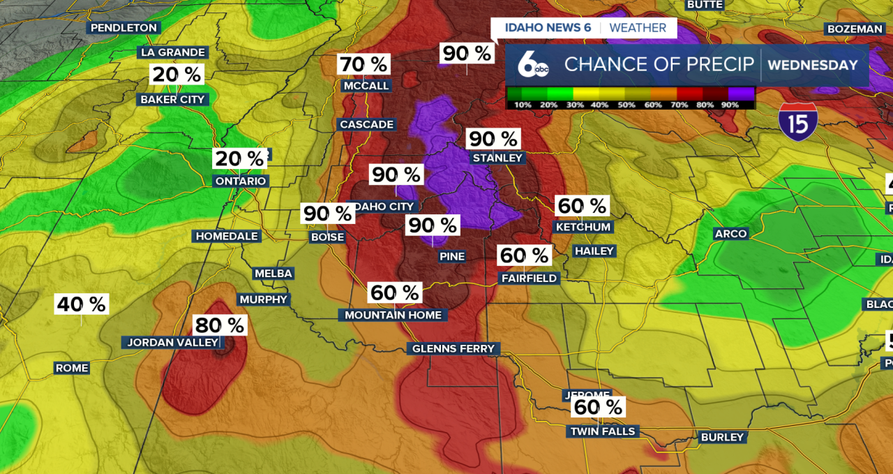
❄️ Snow Levels
This morning, snow levels sit around 6,000–7,500 ft, but they’ll fall to 4,000–5,500 ft by this afternoon behind the front. This does mean fresh powder is in sight! Areas above 6,000 ft will gain 1"-3" of snow, anything below has the potential to see up to an inch.
Warnings/Advisories

An Avalanche Warning remains in effect for the West Central Mountains through noon today. Backcountry travel is not recommended.
Warm, wet, and heavy snow will make natural and human-triggered avalanches likely. Even if you're riding snowmobiles or sticking near groomed terrain, conditions can still be dangerous — so use extreme caution.
A Winter Weather Advisory continues for the East Central Mountains through 5 PM. An additional 5 inches of snow is expected, along with gusty winds that could reduce visibility at times and make travel difficult.
And a Wind Advisory is in effect across southeast Idaho, where wind gusts could reach up to 55 mph. Secure any loose outdoor items and use caution if you’re traveling, especially in high-profile vehicles.
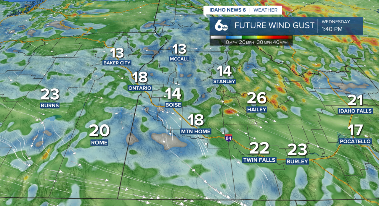
💨 The Bigger Story: Wind
As the front moves through, winds will turn gusty.
Post-frontal winds ramp up this afternoon with gusts across much of the area between 20 and 35 mph. The strongest winds will be across the Magic Valley and Camas Prairie, where gusts could reach up to 45 mph.
A Wind Advisory remains in place through 8 PM this evening for portions of southeast Idaho.
Unsecured objects could be blown around, so make sure to secure any loose outdoor items today.
🌤️ Looking Ahead
NW flow returns Thursday and Friday as a ridge builds along the coast. That pattern keeps us fairly dry heading into the weekend.
We’ll see mainly dry conditions with just some passing high clouds at times.
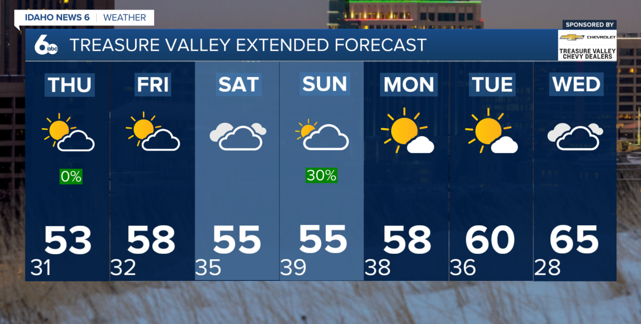
Temperatures will rebound back to near normal on Thursday, then climb to slightly above normal by Friday.
There is the potential for another round of showers heading into Saturday afternoon and Sunday. Right now, it looks very light and spotty, but we’ll continue to watch it as we head into the weekend.