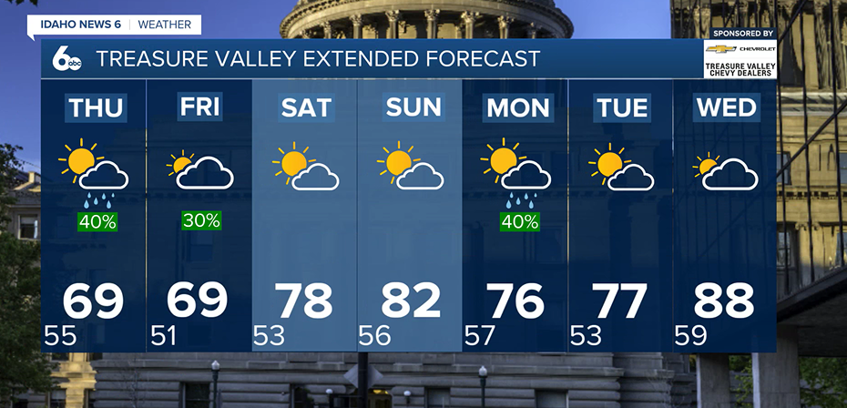
A major change in the weather pattern is underway across southwest Idaho and southeast Oregon, bringing widespread rain, thunderstorms and cooler temperatures through the end of the week.
Wednesday: Storm chances increase
Isolated to scattered showers and thunderstorms are possible Wednesday morning, with most of the activity initially focused across the central Idaho mountains.
Rain chances will increase later Wednesday as a large area of low pressure approaches the Pacific Northwest and pulls more moisture into the region.
By Wednesday night, showers will become more widespread across southeast Oregon and west-central Idaho before spreading across more of the region Thursday.
Thursday: Widespread rain and much cooler
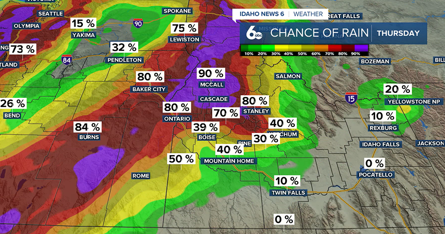
Thursday will be the wettest and coolest day of the week for many locations. Pack the umbrella everyone!
Widespread showers and a few embedded thunderstorms are expected across much of southeast Oregon and southwest Idaho. Periods of rain could continue throughout the day, although rainfall amounts will vary depending on location.
The mountains could pick up around an inch of rain through Friday, with locally higher amounts possible underneath thunderstorms. Valley locations could generally see around a quarter-inch.
The Treasure Valley may initially see lower rainfall totals because surrounding terrain could limit some of the moisture reaching the valley. Rain chances should improve as the atmosphere becomes more saturated.
Recent burn scars will need to be watched, as periods of heavier rain could lead to localized flooding or debris-flow concerns.
Temperatures will also take a significant hit. Highs Thursday are expected to run about 10 to 20 degrees below normal, with record or near-record cool daytime temperatures possible in southeast Oregon and Idaho's West Central Mountains.
Friday: Cool and showery
Periods of rain will continue into Friday as the large area of low pressure remains over the Pacific Northwest.
Temperatures will stay well below normal, and occasional gusty winds will add to the fall-like feel.
Weekend: More unsettled weather possible
Showers will remain possible Saturday, especially across the mountains.
Another round of wetter weather could arrive Sunday as the storm system moves east. There is also a possibility that moisture associated with Hurricane Marie could become pulled into the region, potentially increasing rainfall across south-central Idaho.
There is still considerable uncertainty surrounding how much tropical moisture reaches the region, so rainfall amounts and locations could change.
Cooler weather and additional showers are expected Monday as the main system moves through. Snow levels could even fall low enough for a little snow or a rain-snow mix across the highest mountain peaks.