Good morning, everyone!
Prepare for active weather today.
If today feels completely different from Memorial Day, you’re not imagining it. A slow-moving area of low pressure settling near the Pacific Northwest is bringing a sharp cool down and several days of active weather to southwest Idaho and southeast Oregon.
Temperatures in southwest Idaho will cool by roughly 10 to 20 degrees. That means areas nearing the 90s earlier this week will instead see much cooler conditions, with clouds, wind, and showers replacing the summer-like warmth.
Rain develops through Tuesday across southeast Oregon, with the steadiest precipitation expected closer to Harney County. Higher elevations above 5,500 to 7,000 feet may see snow accumulation, creating slick conditions on mountain roads and potentially impacting anyone recreating, camping, or traveling through higher terrain.
By Tuesday afternoon and evening, attention shifts to thunderstorm development over the mountains of southwest Idaho. While storms are expected to stay primarily in higher elevations, there is around a 20% chance isolated storms drift west toward lower valleys, including areas near the Treasure Valley.

The biggest concern with these storms won’t necessarily be widespread rain or flooding, but rather sudden, localized impacts. Thunderstorms may produce:
- Wind gusts between 40 and 60 mph
- Blowing dust, quickly reducing visibility on roadways
- Small hail
- Brief periods of heavy rainfall
- Rapid changes in weather conditions over short distances
Drivers should be especially cautious this evening. Strong outflow winds from thunderstorms can occur miles away from rainfall and may create dangerous travel conditions, particularly on open roadways. High-profile vehicles such as trucks, trailers, and RVs may experience difficult driving conditions in gusty crosswinds.
Outside of thunderstorms, widespread northwest wind gusts between 30 and 45 mph are expected Tuesday evening due to a tightening pressure gradient. Those stronger winds may blow around unsecured outdoor items and could cause isolated power interruptions where stronger gusts combine with weakened tree limbs.

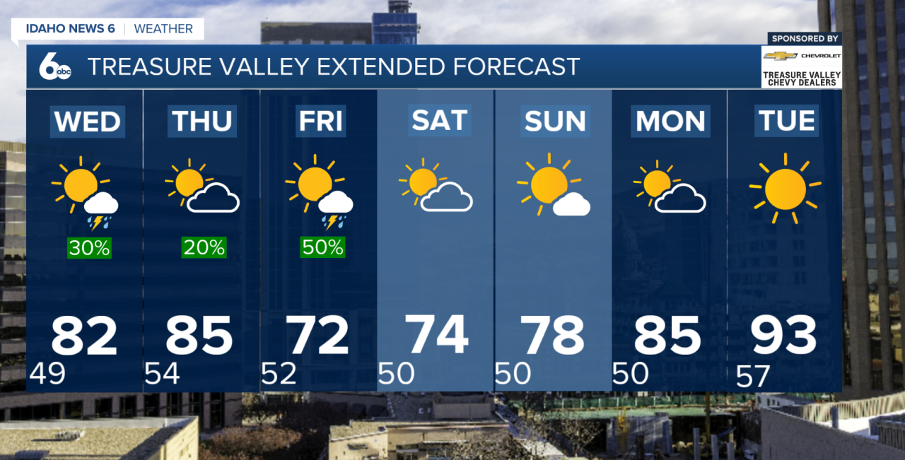
The active weather pattern doesn’t end after Tuesday. The same slow-moving low pressure system is expected to stall near California and Nevada through midweek, continuing rounds of showers and thunderstorms Wednesday through Sunday. Afternoon and evening storms remain most likely in mountain areas, though stronger storms later this week could again produce hail and gusty winds.
Temperatures will gradually recover through the second half of the week but generally remain near or below average into the weekend. By early next week, warmer and drier conditions are expected to return as high pressure builds back into the region.
For now, the biggest adjustment may simply be trading summer-like heat for jackets, umbrellas, and keeping an eye on the sky through the rest of the week.