After Tuesday’s record-breaking heat, southern Idaho is seeing a major weather turnaround today as a strong cold front pushes through the region, bringing gusty winds, blowing dust, thunderstorms, and much cooler temperatures. Wind gusts could reach up to 55 mph across much of southern Idaho, while stronger thunderstorms developing in the Western Magic Valley this afternoon may produce outflow winds as high as 65 mph. Areas that stay dry ahead of the rain could also see pockets of blowing dust reducing visibility at times.
A wind advisory is in effect for Eastern Oregon and Southern Idaho from noon to midnight Wednesday. Gusts have the potential to be up to 55 mph, but Microbursts in stronger storms have the potential to see gusts up to 65 mph. This is considered damaging winds; secure loose items around the home.

Temperatures are running dramatically cooler behind the front, dropping nearly 20 to 25 degrees compared to Tuesday’s heat. Highs today will range from the mid-60s in southeast Oregon to the low 80s further east in the Magic Valley before cooler air fully moves in. Thunderstorms are expected to increase through the late morning and afternoon as the front sweeps east. The strongest storms will be capable of producing dry microbursts and damaging wind gusts, especially between 2 and 4 p.m. in the Western Magic Valley. The combination of strong winds, dry air, and lightning may also create an elevated wildfire risk across parts of south-central Idaho.


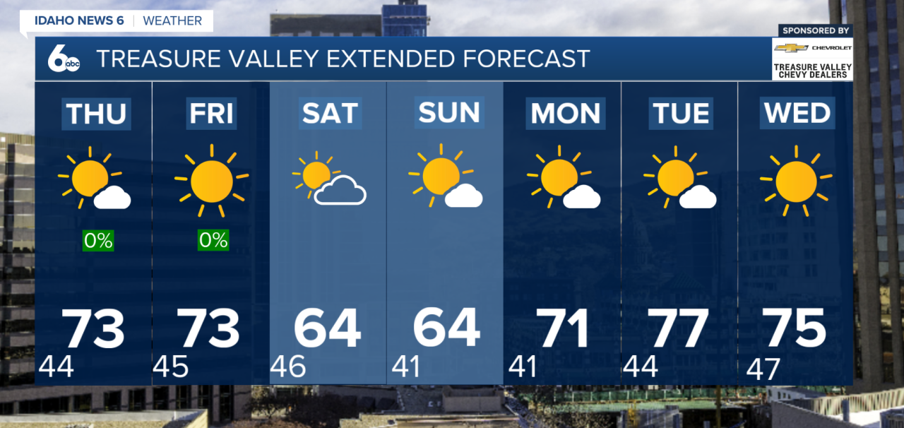
Showers will continue into Wednesday night and early Thursday, especially in the mountains, where snow levels could briefly fall to around 6,000 to 7,000 feet. Thursday stays breezy and much cooler with highs mainly in the 60s before drier weather and more seasonable temperatures return Friday. Sunshine increases Friday with highs recovering back into the upper 60s and low 70s, although overnight temperatures will remain chilly with many locations falling into the 30s and 40s.
The cooler pattern continues into the weekend as another large trough drops south from British Columbia, bringing another noticeable cooldown Saturday through Sunday. Daytime highs are expected to fall 5 to 10 degrees below normal with breezy conditions continuing. While widespread rain is not expected, isolated mountain showers will still be possible, especially across west-central and southwest Idaho. Looking ahead to next week, a drier west-to-northwest flow returns with temperatures gradually warming back toward seasonal averages through midweek.