We are wrapping up another round of valley rain and mountain snow this Friday morning as a low-pressure system continues to push across our region. While most of this precipitation will taper off by late morning, some of our higher elevations are still picking up additional snowfall.
Now, the big question this morning is whether we could see snow make it down to the Treasure Valley floor. Some of our higher-resolution models have hinted at that possibility, even showing up to 1.4 inches in Boise. However, the National Weather Service puts the chance of that happening at less than 10%. With warmer air still in place, rain is expected to remain the predominant precipitation type across the Treasure Valley.
Snow levels are generally sitting around 3,500 to 4,000 feet, with the greatest snowfall totals expected south and west of the Snake River Valley. These higher elevations could pick up another 2–4 inches of snow through late morning. Meanwhile, ridgetops above 7,000 feet in the Owyhees, Steens Mountains, and near the Idaho-Nevada border could see an additional 6–10 inches.
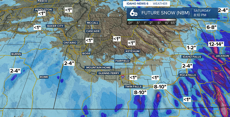
A Winter Weather Advisory remains in effect until 11 a.m. for Malheur County, the Owyhee Mountains, and western portions of the Southern Highlands. If you are heading out along Highways 51 or 95, be prepared for snow-covered roads and reduced visibility, especially near Ion Summit.
As this system moves out, we are not completely done with the impacts. Winds will pick up across portions of the Magic Valley and southern Baker County, with gusts reaching up to 35 mph this afternoon.
A Brief Break Before Our Next Storm
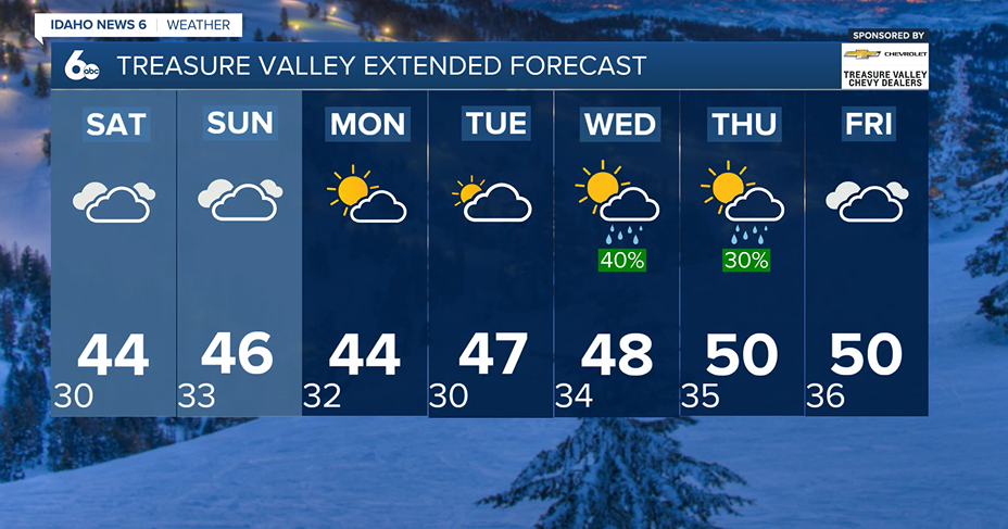
The good news is that we will catch a break from the wet weather heading into Saturday! High pressure will briefly build over the region, allowing for drier conditions. However, temperatures will remain on the cooler side, with overnight lows dropping below freezing across the region starting Saturday night.
That break will not last long. Another system moves in late Sunday, bringing another round of valley rain and mountain snow. With colder temperatures in place, we could even see a rain-snow mix reach some of our lower elevations early Sunday morning.
Showers could linger into Monday morning before we catch another brief break heading into Tuesday.
What About Thanksgiving?
Looking ahead to Thanksgiving week, we are keeping a close eye on another system approaching the Pacific Northwest.
An atmospheric river is expected to approach the coast around Wednesday, but the main system looks to stay offshore. However, some of that leftover moisture could still make its way into our region, bringing another round of valley rain and mountain snow, especially across southeast Oregon and the higher elevations of southwest Idaho.
There is still quite a bit of uncertainty heading into Thanksgiving Day. Right now, forecast models are struggling to agree on how this system will evolve. The current forecast leans toward a warmer and drier scenario, but we will continue to watch how things develop over the next several days.
Bottom line: We are not quite done with this active weather pattern! Expect a few breaks from the rain and snow, but overall, cooler and unsettled conditions will stick around as we head toward Thanksgiving.