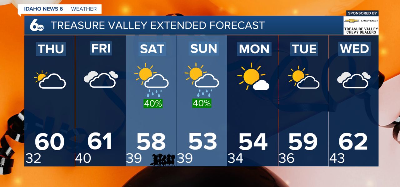
Southwest Idaho is getting a break from the unsettled weather this week, but another storm system is expected to arrive just in time for Halloween. After a few dry and seasonable days, rain chances will increase heading into the weekend, with mountain snow also making a return.
Wednesday: Clearing Skies and Chilly Temperatures
Skies will gradually clear Wednesday as the latest storm system moves out of the region. However, recent rainfall and cooler overnight temperatures could lead to areas of patchy fog or freezing fog during the morning commute, especially in sheltered valleys.
Afternoon temperatures will remain close to seasonal averages, with highs generally in the 50s across lower elevations. Higher elevations and portions of eastern Oregon will stay cooler, with highs in the 40s.
Thursday: A Cold Start, Followed by a Warmer Afternoon
Thursday morning will bring some of the coldest temperatures of the week. Many lower-elevation communities could wake up to temperatures near or below freezing, while some higher valleys may drop into the teens.
Despite the chilly start, afternoon temperatures will climb about 5 degrees warmer than Wednesday. Expect mostly dry conditions with increasing high clouds throughout the day.
Friday: Rain Chances Begin to Return
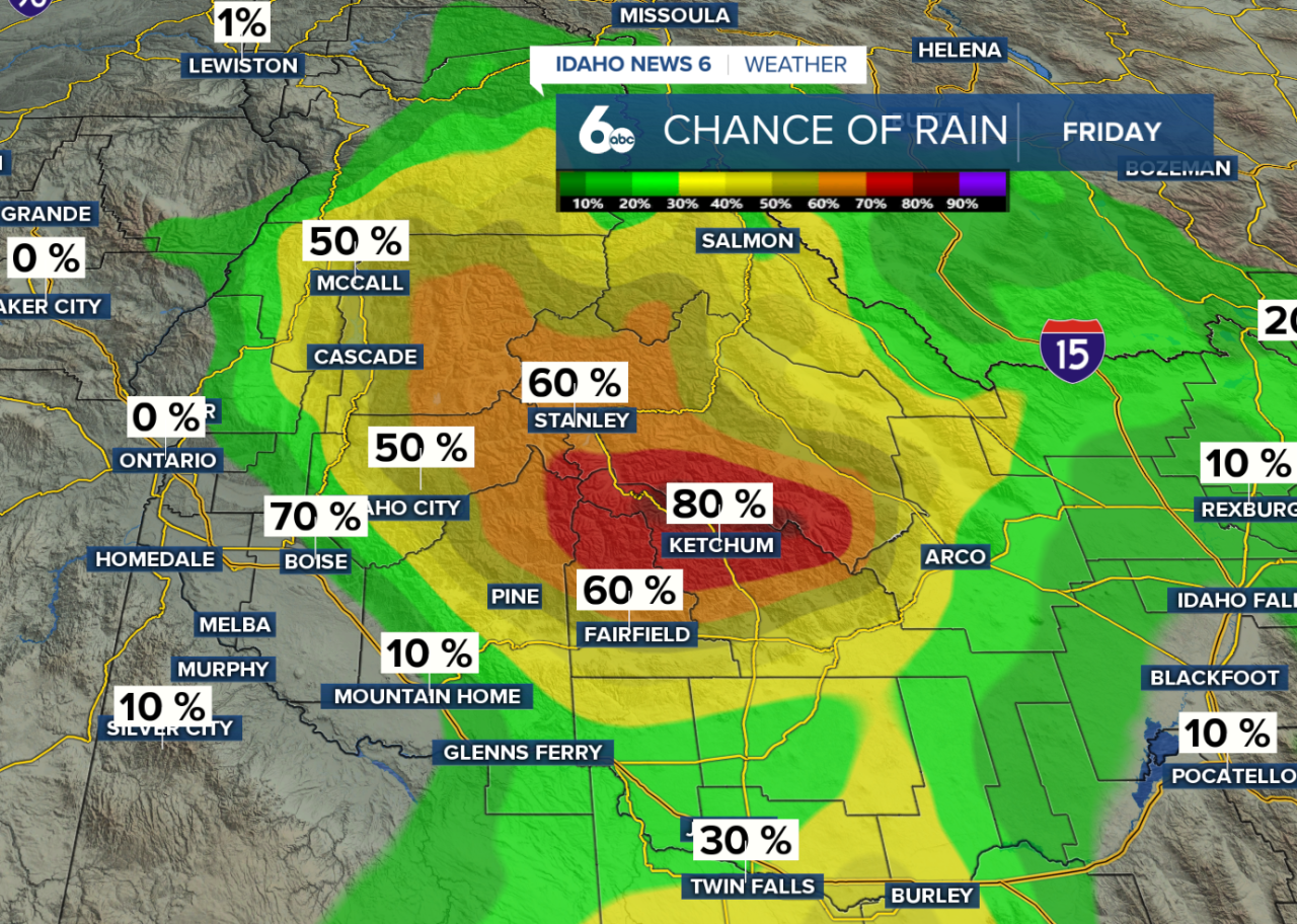
Changes arrive Friday as another Pacific storm system approaches the region. The first precipitation chances will develop across the central Idaho mountains, with most valley communities remaining dry for much of the day.
Snow levels will initially stay elevated, with a light dusting to an inch possible above 6,000 feet.
Halloween Saturday: Rain Could Interrupt Trick-or-Treating
If you're planning to head outdoors for Halloween, you'll want to keep an umbrella handy!
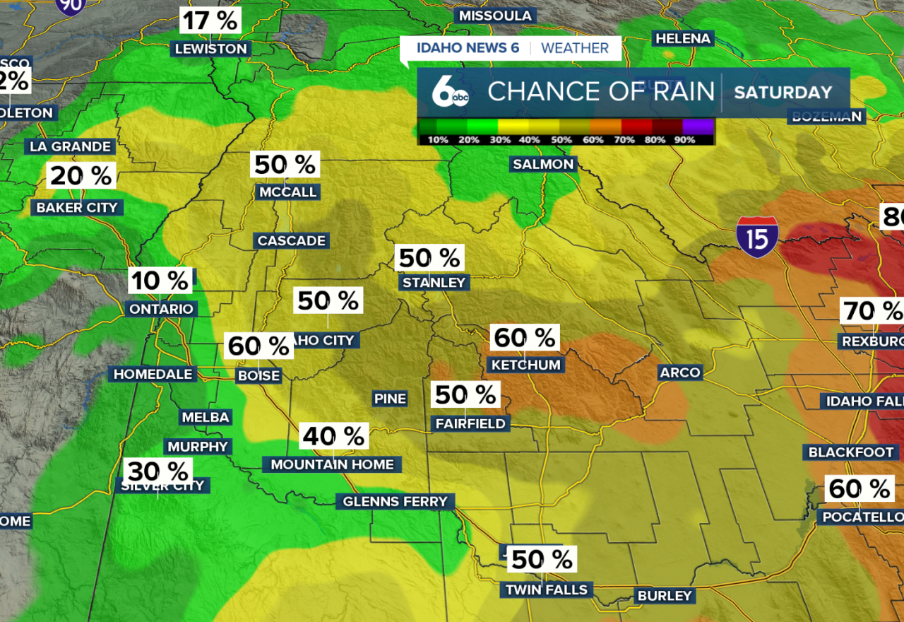
Rain chances will increase throughout Saturday as a cold front moves across southwest Idaho. The greatest chance for widespread precipitation arrives Saturday evening and overnight, with a 50–80% chance of precipitation across the region.
That means trick-or-treaters could encounter rainy conditions, particularly during the evening (trick-or-treating) hours.
Snow levels will initially range between 6,000 and 8,000 feet, keeping most lower-elevation communities dealing with rain rather than snow.
Sunday: Cooler Temperatures and Mountain Snow
Behind Saturday's cold front, temperatures will cool and snow levels will drop to between 4,500 and 6,500 feet by Sunday afternoon.
Most mountain snow accumulation will occur above 6,500 feet, where 2–5 inches are possible, with locally higher amounts nearing 7 inches on the tallest peaks.
Some locations as low as 4,500 feet could briefly see snow or a rain-snow mix, although significant accumulation is unlikely as precipitation begins to taper off.
Next Week: Drier and Gradually Warmer
The unsettled pattern won't stick around for long. High pressure will begin building into the region Monday, bringing a return to drier conditions by the afternoon.
Temperatures will gradually warm heading into the middle of next week, with dry weather expected to continue through at least Wednesday.
Enjoy the dry weather through Thursday, prepare for increasing rain chances Friday into Halloween Saturday, and expect cooler temperatures with mountain snow Sunday. A drier and warmer pattern returns next week.