


Happy Monday! We’re starting off on a colder note this morning — especially in those higher elevation valleys where temperatures dipped below freezing overnight.
But don’t get used to it… We’re warming up fast.
High temperatures today
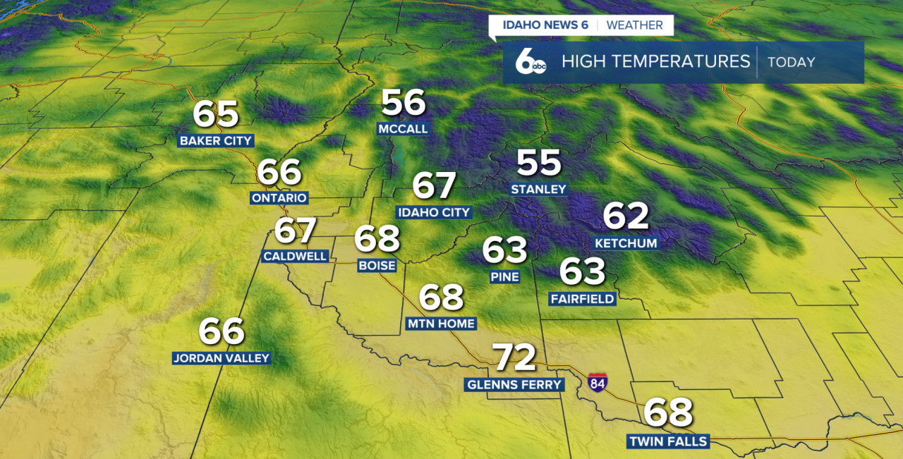
By this afternoon, we’re already climbing above normal under a mix of sun and a light breeze, and this is just the start of a much warmer stretch. Highs will continue rising into the mid 70s by Tuesday and Wednesday — about 10 to 15 degrees above average.
Now, while today stays pretty quiet, things do start to change heading into tomorrow.
Forecast: Get ready for a temperature roller coaster this week
A cold front moves in late Tuesday into Wednesday, and ahead of it, winds are going to pick up. The strongest gusts — up to 50 mph — will be near the Oregon-Nevada border. Pair that with really dry air and single-digit humidity, and that’s going to bring elevated fire danger Tuesday and Wednesday afternoon.
As that front moves through, we’ll also see a few mountain showers develop, mainly across eastern Oregon and the West Central Mountains. Behind it, temperatures cool off slightly and snow levels drop pretty quickly — from above 8,000 feet down to around 4,000 to 5,000 feet by Wednesday night.
That means some light snow is possible in the higher elevations, especially in northern Valley County, but overall impacts look pretty minor.
McCall Forecast: Rain chances Tuesday and Wednesday

Looking ahead, Thursday brings a slight chance of a few leftover mountain showers along with breezy conditions — especially from Mountain Home through the Western Magic Valley.
Then… we warm right back up.
By Friday and into the weekend, another ridge builds in and temperatures climb back above normal — about 5 to 15 degrees above average.
There are hints at a pattern change by Monday with a trough trying to move in, but this could change as we get closer.
Treasure Valley Extended Forecast
