


Good morning, everyone! I hope the work week has started on a good note for you.
It’s been feeling more like late spring than early March, and that trend isn’t going anywhere just yet. Warm temperatures continue across southwest Idaho and southeast Oregon through midweek, with many valley locations climbing into the mid-70s. A few warmer spots could even approach 80 degrees, putting several areas close to record highs.

According to records from the National Weather Service, Boise, Burns, and Jerome have the potential to set new records this afternoon and on Wednesday.
Afternoon Highs Tuesday & Wednesday


Fire concerns
This stretch of warmth is being driven by a strong ridge of high pressure, pulling in a much warmer air mass from the south. But while the sunshine and mild conditions may feel nice, they also raise concerns.
Gusty winds combined with very dry air will elevate fire danger, particularly near the Nevada border today and Wednesday afternoon. Wind gusts could reach between 25 and 45 mph across open areas, creating conditions that allow fires to spread more easily — especially after several days of warm, dry weather.
Rain/snow chances
Meanwhile, not everyone will stay completely dry. Areas further north, including Baker County and the west-central Idaho mountains, will sit closer to a storm track. These locations will see a 30–60% chance of showers through Wednesday, although rainfall totals are expected to remain light. Snow levels will stay high, above 8,000 feet, limiting impacts to the highest elevations.
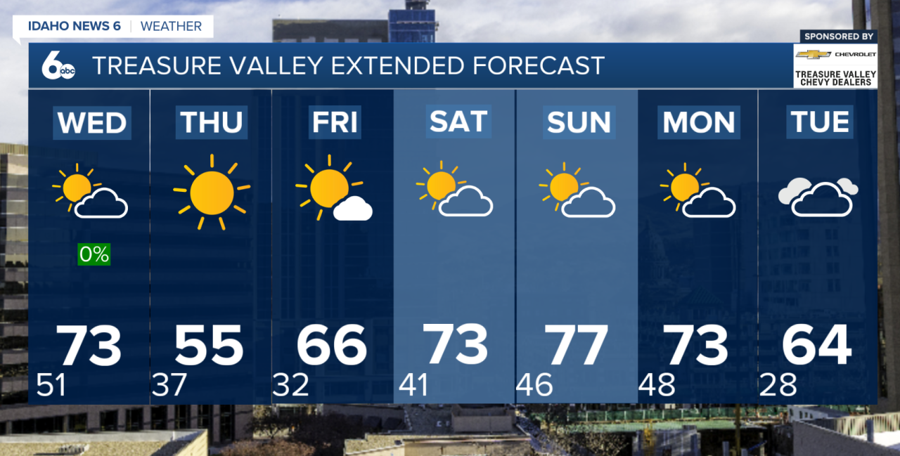
Forecast ahead: From near record highs to mid-week cool down
A shift arrives late Wednesday as a cold front moves through the region. While this front won’t bring widespread precipitation, it will usher in another round of gusty winds — especially along the I-84 corridor — followed by a noticeable drop in temperatures.
By Thursday, highs will fall anywhere from 10 to 25 degrees compared to earlier in the week, bringing temperatures closer to seasonal norms and a much cooler feel overall.
The cooldown won’t last long. Heading into the weekend, a weaker ridge builds back in, allowing temperatures to rebound steadily. By Sunday, highs are once again expected to reach the low to mid-70s across the valleys under mostly dry conditions.
Looking ahead to early next week, another system begins to approach the Pacific Northwest, bringing increasing chances for mountain showers by Monday and a broader chance of precipitation across the region by Tuesday.
From near-record warmth to a sharp cooldown and back again, it’s a classic case of springtime weather whiplash.
Treasure Valley Extended Forecast
McCall Forecast
