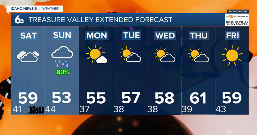
A soggy Halloween weekend is ahead for southwest Idaho, with scattered showers Friday before a stronger storm brings widespread rain, mountain snow, and gusty winds Saturday night into Sunday. Trick-or-treaters may want to keep an umbrella handy!
Friday: Scattered Showers and Near-Normal Temperatures
Friday will bring a mix of clouds and scattered rain showers across southwest Idaho, mainly from late morning through the afternoon. Most valley locations will see light rainfall, with totals staying below a tenth of an inch. Higher elevations could pick up between 0.10 and 0.25 inches of precipitation, with light snow possible above 7,000 feet.
Afternoon highs will reach the mid to upper 50s across the lower valleys, with generally light winds. Showers should wrap up by the evening, allowing for a mostly dry Friday night. However, patchy fog could develop overnight, especially in areas that receive rainfall.
Saturday: Will Rain Impact Trick-or-Treating?
Halloween will start off relatively quiet, but conditions will become increasingly unsettled as the day progresses.
A few scattered showers are possible during the afternoon, but the more widespread rainfall is expected to arrive Saturday evening and continue overnight.
For families heading out trick-or-treating Saturday evening, plan for the possibility of rain! Rain chances will increase throughout the evening, with a 60–90% chance of precipitation across much of the region as the storm moves northward. There is also a 15–25% chance of thunderstorms across southern Idaho late Saturday afternoon and evening, which could produce locally heavier downpours.
Temperatures will be similar to Friday, with afternoon highs in the mid to upper 50s. Evening temperatures will be cooler, so an extra layer underneath Halloween costumes and a waterproof jacket would be a good idea.
While Halloween afternoon may offer some drier opportunities for outdoor festivities, the later you stay out Saturday evening, the greater the potential for wet weather.
Sunday: Widespread Rain, Mountain Snow, and Gusty Winds
Sunday will likely be the most active weather day of the weekend as a cold front moves across the region.
Widespread precipitation will continue into Sunday before gradually tapering off from west to east.
Rainfall totals across southwest Idaho's lower valleys are expected to range from 0.25 to 0.50 inches. However, there is a 10–20% chance that the Boise metro could receive an inch or more.
The mountains east of Boise could pick up between 0.50 and 1 inch of precipitation, with locally higher amounts possible. Snow levels will initially range from 6,500 to 8,000 feet before dropping to around 5,500–6,500 feet Sunday morning.
Several inches of heavy, wet snow will be possible above 7,000–8,000 feet, with lighter accumulations reaching elevations near 6,000 feet.
Behind the cold front, temperatures will drop approximately 5–10 degrees compared to Saturday. Gusty winds will also develop Sunday afternoon, particularly east of Boise into the Magic Valley, where gusts of 30–45 mph will be possible into Sunday night.
Next Week: Drier and Warmer Weather Returns
The unsettled pattern will move out by Monday as high pressure builds across the region.
Dry conditions are expected Monday through Wednesday, with temperatures gradually warming to near or slightly above seasonal averages. Winds will generally remain light.
By Thursday and Friday, another couple of weak disturbances could bring a 10–30% chance of showers back to southwest Idaho.
For now, the biggest weather concern is Halloween weekend, especially Saturday evening through Sunday, when widespread rain, high-elevation snow, and gusty winds will make for a chilly and unsettled start to November.