

FROST ADVISORY:
High clouds are moving in this morning ahead of the next weather system. However, they’re thin enough that pockets of frost are still expected—especially east of Boise and into the Western Magic Valley, where temperatures will dip into the mid to upper 30s. Cover sensitive plants and crops!

TODAY:
This afternoon, a fast-moving trough passes just north of the region, keeping the area mostly dry with a slight chance of showers in the West Central Mountains. Temperatures will rebound a few degrees, landing near seasonal averages, but expect another breezy day.
With clearing skies and lighter winds tonight, frost becomes more likely. A Frost Advisory is in effect for the entire Treasure Valley and Western Magic Valley for Saturday morning also, with lows between 33–37°.
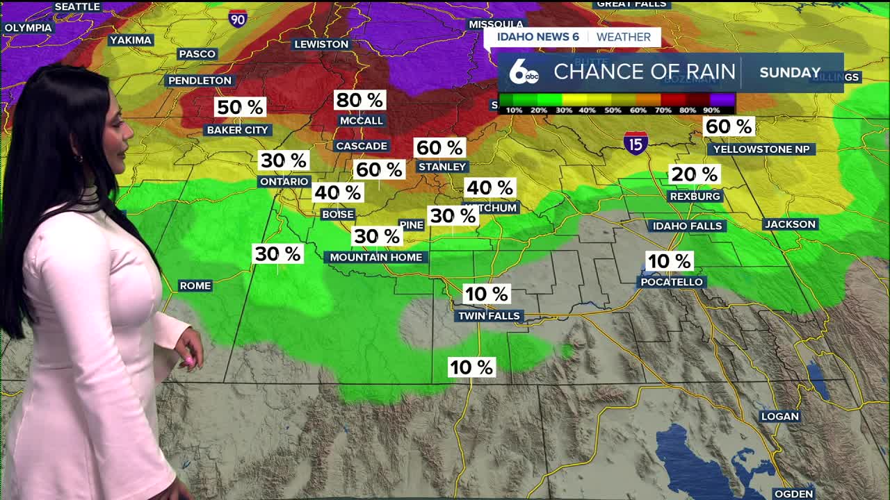
WEEKEND:
Saturday brings the return of lighter winds and mostly sunny skies—before the next cold front arrives Sunday afternoon. That system will bring stronger winds, a drop in temperatures, and a 30–60% chance of rain and light mountain snow above 6,500 feet.

NEXT WEEK:
Looking into next week, a stronger trough settles in over the Northwest, bringing cooler air and scattered mountain showers Monday. A warming, drying trend follows through midweek before models hint at a bigger system late week that could deliver widespread rain, mountain snow, and a sharper temperature drop.
Stay up to date right here https://www.instagram.com/sophiacruzwx/
Friday
Mostly cloudy through mid morning, then gradual clearing, with a high near 64. Calm wind becoming northwest around 6 mph in the afternoon.
Friday Night
Mostly clear, with a low around 35. North wind around 6 mph becoming west in the evening.
Saturday
Sunny, with a high near 63. West northwest wind around 5 mph becoming calm in the morning.
Saturday Night
Mostly clear, with a low around 43. East southeast wind 5 to 10 mph.
Sunday
A 30% chance of showers. Partly sunny, with a high near 64.
Sunday Night
Mostly clear, with a low around 34.
Monday
Sunny, with a high near 56.
Tuesday
Mostly sunny, with a high near 59.
Wednesday
Sunny, with a high near 60.
Thursday
Mostly sunny, with a high near 64.